Castasegna
| Castasegna | ||
|---|---|---|
| Former municipality of Switzerland | ||

Castasegna village
|
||
|
||
| Coordinates: 46°20′N 9°31′E / 46.333°N 9.517°ECoordinates: 46°20′N 9°31′E / 46.333°N 9.517°E | ||
| Country | Switzerland | |
| Canton | Graubünden | |
| District | Maloja | |
| Area | ||
| • Total | 6.76 km2 (2.61 sq mi) | |
| Elevation | 696 m (2,283 ft) | |
| Population | ||
| • Total | 191 | |
| • Density | 28/km2 (73/sq mi) | |
| Postal code | 7608 | |
| SFOS number | 3773 | |
| Surrounded by | Bondo, Soglio, Villa di Chiavenna (IT-SO) | |
| Website | SFSO statistics |
|
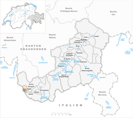
Castasegna (![]() [kɐʃtɐˈzeɲɐ] ) is a former municipality in the district of Maloja in the Swiss canton of Grisons, right at the Italian border. It's now part of the municipality of Bregaglia. The town is situated in the Bergell valley, above the river Mera.
[kɐʃtɐˈzeɲɐ] ) is a former municipality in the district of Maloja in the Swiss canton of Grisons, right at the Italian border. It's now part of the municipality of Bregaglia. The town is situated in the Bergell valley, above the river Mera.
Castasegna is first mentioned in 1374 as Castexegnia.
Castasegna has an area, as of 2006[update], of 6.8 km2 (2.6 sq mi). Of this area, 19.2% is used for agricultural purposes, while 40.1% is forested. Of the rest of the land, 2.1% is settled (buildings or roads) and the remainder (38.6%) is non-productive (rivers, glaciers or mountains).
The municipality is located in the Bergell sub-district of the Maloja district in the lower section of the Bergell valley. It consists of the linear village of Castasegna with the Italian border on the edge of town and the neighboring Italian village of Villa di Chiavenna nearby. The main highway in the valley used to run through the main, narrow street. In order to relieve the town of the congestion, the highway was moved just below, along the valley floor.
On 1 January 2010 the municipalities of Bondo, Castasegna, Soglio, Stampa, and Vicosoprano merged into a new municipality of as Bregaglia.
...
Wikipedia


