Carnduff, Saskatchewan
| Carnduff | |
|---|---|
| Town | |

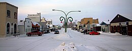
Downtown Carnduff
|
|
| Motto: "A community on the move" | |
| Location of Carnduff | |
| Coordinates: 49°10′01″N 101°46′59″W / 49.167°N 101.783°W | |
| Country | Canada |
| Province | Saskatchewan |
| Region | Saskatchewan |
| Rural Municipality | Mount Pleasant No. 2 |
| Post Office Established | 1884-09-01 |
| Government | |
| • Mayor | Ross Apperley |
| • Administrator | Annette Brown |
| • Governing body | Carnduff Town Council |
| Area | |
| • Total | 2.26 km2 (0.87 sq mi) |
| Population (2011) | |
| • Total | 1,126 |
| • Density | 192.0/km2 (497.3/sq mi) |
| Time zone | CST (winter) / MST (summer) |
| Postal code | S0C 0S0 |
| Area code(s) | 306 |
Carnduff is a small agricultural town in Southeastern Saskatchewan, Canada.
Carnduff is named after its first postmaster, John Carnduff. It was marked on early CPR maps, though that location did not exactly correspond to the present town site later surveyed in 1891.
Though Saskatchewan is in the CST Zone, since 1967 it has not observed daylight saving time and the local clocks do not get changed in summer. A practical effect on border towns like Carnduff is that they only align with neighbouring communities in Manitoba and North Dakota for half the year, which may lead to misunderstandings regarding the timing of scheduled inter-community events.
In 2001, the town was noted as having trees affected by Dutch Elm Disease.
The town lies at the intersection of Highway 318 and Highway 18. The Canadian Pacific Railway runs parallel to Highway 18 and their combined thoroughfare splits the town into a north half and a south half. The majority of housing and businesses are in the southern half of the town, while the northern half has a majority of the recreation facilities and larger industrial buildings. The Antler River flows around the north side and east of the town, adding a small valley to the otherwise flat local flat prairie.
Severe flooding in the Souris River basin region during the spring and summer of 2011 caused damage to bridges over the Antler River north and east of the town. Significant repair work was required on the Highway 18 bridge near the Viterra terminal.
The nearest locations with a population larger than 10,000 are Estevan 90 km to the west, and Minot, North Dakota 140 km to the southeast. The provincial capital, Regina, is approximately three hours northwest by highway.
...
Wikipedia


