Caraz District
| Caraz | |||
|---|---|---|---|
| District | |||

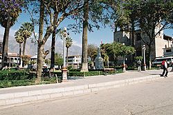
Central plaza of Caraz
|
|||
|
|||
 Location of Caraz in the Huaylas province |
|||
| Country |
|
||
| Region | Ancash | ||
| Province | Huaylas | ||
| Founded | December 29, 1856 | ||
| Capital | Caraz | ||
| Subdivisions | 13 | ||
| Government | |||
| • Mayor | Fidel Mario Broncano Vasquez | ||
| Elevation | 2,285 m (7,497 ft) | ||
| Population (1981 census) | |||
| • Total | 14,544 | ||
| Time zone | PET (UTC-5) | ||
| UBIGEO | 021201 | ||
| Website | municaraz.gob.pe | ||
The Caraz District (Spanish: Distrito de Caraz) is one of 10 districts of the Huaylas Province in the Ancash Region of Peru. The capital of the district is Caraz. It is located at 2,235 msnm. In Caraz the paved road that comes from Pativilca ends.
The snow-capped mountains of Tullparahu (6,356 m), Pukarahu (6,259 m), Allpamayu (6,120 m) and others, constitute a splendid frame for the city. Near Parun Lake the snow summits are reflected. There are also mineral-medicinal springs like Colca and Shongor.
The settlers produce wool textiles, carpets, ponchos, straw fabrics and the renowned fruit and manjarblanco sweets known as cuarteados.
Departing from Caraz to the north, the Santa River is crossed to arrive to the Cañón del Pato. The Callejón de Huaylas has become narrow between the highest and vertical walls of rock, without any vegetation and, in this stretch, the rocks of the Cordillera Blanca and Cordillera Negra come closer (less than 5 m of distance).
To arrive to Huallanca, at the north end of the Callejón de Huaylas, 33 tunnels must be passed in a trip of 25 km, in which the Santa River breaks, roaring, the Cordillera Negra, to flow to the sea.
...
Wikipedia


