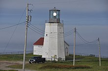
Cape St. Mary's

Cape St. Mary's Lighthouse
|
|
|
Location of Cape St. Mary's in Newfoundland
|
|
| Location | Cape St. Mary's Avalon Peninsula Newfoundland Canada |
|---|---|
| Coordinates | 46°49′23.0″N 54°11′45.9″W / 46.823056°N 54.196083°W |
| Year first constructed | 1860 |
| Foundation | concrete base |
| Construction | cast iron encased in concrete tower |
| Tower shape | octagonal frustum tower with balcony and lantern |
| Markings / pattern | white tower, grey metallic lantern |
| Height | 11.5 metres (38 ft) |
| Focal height | 119 metres (390 ft) |
| Light source | solar power |
| Range | 21 nautical miles (39 km; 24 mi) |
| Characteristic | Fl W 5s. |
| Fog signal | 1 blast every 30s. |
| Admiralty number | H0432 |
| CHS number | CCG 14 |
| NGA number | 1952 |
| ARLHS number | CAN-721 |
| Managing agent | Cape St. Mary's Ecological Reserve |
The headland of Cape St. Mary's is located at the southern tip of the south-western arm of the Avalon Peninsula of the island of Newfoundland in the Canadian province of Newfoundland and Labrador.
Cape St. Mary's is probably one of the most well known capes of the province, it has been written in song and history. There is a well known folk song about the Cape called "Let Me Fish Off Cape St. Mary's" by Otto P. Kelland.
The Cape St. Mary's Ecological Reserve is a wildlife reserve located east of the Cape. The Friends of Cape St. Mary's is a non-profit organisation of persons who are engaged in sharing the colourful and diverse elements of the ecological reserve.
Coordinates: 46°49′20.35″N 54°11′39.67″W / 46.8223194°N 54.1943528°W
...
Wikipedia

