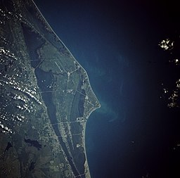
Cape Kennedy
| Cape Canaveral | |
|---|---|

Cape Canaveral from space. August 7, 1991
|
|
| Florida map showing the location of Cape Canaveral | |
| Location | Florida, United States |
| Coordinates | 28°27′20″N 80°31′40″W / 28.45556°N 80.52778°WCoordinates: 28°27′20″N 80°31′40″W / 28.45556°N 80.52778°W |
| Offshore water bodies | Atlantic Ocean, Gulf of Mexico |
| Elevation | 10 ft (3.0 m) |
Cape Canaveral, from the Spanish Cabo Cañaveral, is a cape in Brevard County, Florida, United States, near the center of the state's Atlantic coast. Known as Cape Kennedy from 1963 to 1973, it lies east of Merritt Island, separated from it by the Banana River. It was discovered by the Spanish conquistador Juan Ponce de León in 1513.
It is part of a region known as the Space Coast, and is the site of the Cape Canaveral Air Force Station. Since many U.S. spacecraft have been launched from both the station and the Kennedy Space Center on adjacent Merritt Island, the two are sometimes conflated with each other. In homage to its spacefaring heritage, the Florida Public Service Commission allocated area code 321 (as in a rocket countdown) to the Cape Canaveral area.
Other features of the cape include the Cape Canaveral lighthouse and Port Canaveral, one of the busiest cruise ports in the world. The city of Cape Canaveral lies just south of the Port Canaveral District.Mosquito Lagoon, the Indian River, Merritt Island National Wildlife Refuge and Canaveral National Seashore are also features of this area.
...
Wikipedia

