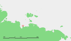
Cape Buor-Khaya
| Cape Buor-Khaya | |
|---|---|
| Мыс Буор-Хая | |

Location of Cape Buor-Khaya
|
|
| Location |
Sakha (Yakutia), |
| Coordinates | 71°56′38″N 132°47′38″E / 71.94389°N 132.79389°ECoordinates: 71°56′38″N 132°47′38″E / 71.94389°N 132.79389°E |
| Offshore water bodies | Laptev Sea |
| Area | Russian Far East |
Cape Buor Khaya, (Russian: Мыс Буор-Хая; Mys Buor-Khaya) is a headland in the Laptev Sea.
It is located between the Buor-Khaya Gulf on the west and the Yana Bay on the east. It is a conspicuous headland and has an 11 m high light on a framework tower.
The sea in the area surrounding the cape is frozen for about nine months every year and often clogged with ice floes. On its eastern side there is a long semi-submerged landspit known as Kosa Buor-Khaya.
Administratively the Buor-Khaya Cape belongs to the Sakha Republic (Yakutia) of the Russian Federation.
...
Wikipedia

