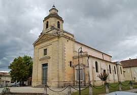
Cantenac
| Cantenac | |
|---|---|
 |
|
| Coordinates: 45°01′45″N 0°39′09″W / 45.0292°N 0.6525°WCoordinates: 45°01′45″N 0°39′09″W / 45.0292°N 0.6525°W | |
| Country | France |
| Region | Nouvelle-Aquitaine |
| Department | Gironde |
| Arrondissement | Lesparre-Médoc |
| Canton | Le Sud-Médoc |
| Area1 | 14.26 km2 (5.51 sq mi) |
| Population (2008)2 | 1,269 |
| • Density | 89/km2 (230/sq mi) |
| Time zone | CET (UTC+1) |
| • Summer (DST) | CEST (UTC+2) |
| INSEE/Postal code | 33091 /33460 |
| Elevation | 1–22 m (3.3–72.2 ft) (avg. 30 m or 98 ft) |
|
1 French Land Register data, which excludes lakes, ponds, glaciers > 1 km² (0.386 sq mi or 247 acres) and river estuaries. 2Population without double counting: residents of multiple communes (e.g., students and military personnel) only counted once. |
|
1 French Land Register data, which excludes lakes, ponds, glaciers > 1 km² (0.386 sq mi or 247 acres) and river estuaries.
Cantenac is a former commune in the Gironde department in Nouvelle-Aquitaine in southwestern France. On 1 January 2017, it was merged into the new commune Margaux-Cantenac. It is located near Bordeaux.
Situated on the Left bank of the Gironde in the region Haut-Médoc, the area is home to many wineries, however following a law of 1954, Cantenac wines fall under the Margaux AOC, as there is no appreciable difference between the two communes. The chateaux of Cantenac that were ranked at the Bordeaux Wine Official Classification of 1855 are:
...
Wikipedia


