Candaba, Pampanga
|
Candaba Vizal Sto Cristo Candaba |
||
|---|---|---|
| Municipality | ||
 |
||
|
||
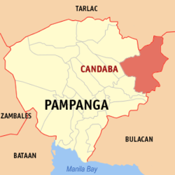
 Map of Pampanga showing the location of Candaba |
||
| Location within the Philippines | ||
| Coordinates: 15°5′36″N 120°49′42″E / 15.09333°N 120.82833°ECoordinates: 15°5′36″N 120°49′42″E / 15.09333°N 120.82833°E | ||
| Country | Philippines | |
| Region | Central Luzon (Region III) | |
| Province | Pampanga | |
| District | 4th District | |
| Barangays | 33 | |
| Government | ||
| • Mayor | Danilo Baylon | |
| Area | ||
| • Total | 176.40 km2 (68.11 sq mi) | |
| Population (2010) | ||
| • Total | 102,399 | |
| • Density | 580/km2 (1,500/sq mi) | |
| Time zone | PST (UTC+8) | |
| ZIP code | 2013 | |
| IDD : area code | +63 (0)45 | |
| Income class | 1st Class | |
Candaba (Kapampangan: Balen ning Candaba; formerly Candawe) is a first-class municipality in the province of Pampanga, Philippines. According to the 2010 census, it has a population of 102,399 people.
Candaba represents the lowest point in Central Luzon Region of Luzon Island. The neighboring municipality of San Miguel (San Miguel de Mayumo) in Bulacan province used to be part of Candaba until San Miguel became a municipality itself.
Candaba's municipal boundaries are: Municipality of Arayat, Pampanga, and Municipality of Cabiao, Nueva Ecija, to the north; Municipality of San Miguel, Bulacan, and Municipality of San Ildefonso, Bulacan, to the east; Municipality of Baliuag, Bulacan, to the south; Municipality of San Luis, Pampanga, and Municipality of Santa Ana, Pampanga, to the west.
Candaba is politically subdivided into 33 barangays.
Like rest of the area in Central Luzon, there are two seasons in the area, the wet season and dry season. The wet season occurs during the months of May to October, and the dry season the rest of the year.
Roman Catholic 60%, Members Church of God International 3.5%, Iglesia ni Cristo 3%, Evangelicals 32%, others (includes Islam, Buddhism and other religions) 1.5%. The Saint Andrew church serves as one of the Roman Catholic parish churches inside the municipality.
...
Wikipedia


