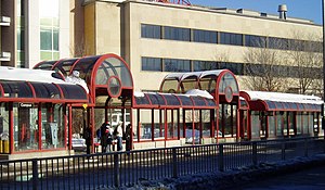
Campus Station (OC Transpo)
|
uOttawa
|
|||||||||||
|---|---|---|---|---|---|---|---|---|---|---|---|
 |
|||||||||||
| Location |
Ottawa, Ontario Canada |
||||||||||
| Coordinates | 45°25′14″N 75°40′56″W / 45.42056°N 75.68222°WCoordinates: 45°25′14″N 75°40′56″W / 45.42056°N 75.68222°W | ||||||||||
| Owned by | OC Transpo | ||||||||||
| Other information | |||||||||||
| Status | Station closed until May 2018. Reopening as LRT station. | ||||||||||
| History | |||||||||||
| Closed | 24 April 2016 | ||||||||||
| Rebuilt | May 2018 | ||||||||||
| Services | |||||||||||
|
|||||||||||
uOttawa Station is a future LRT station on the upcoming O-Train Confederation Line, replacing Campus station, which was a former bus stop on Ottawa's transitway. Located just east of the Rideau Canal at the western terminus of Somerset Street East, the station serviced the University of Ottawa's southern section and the Sandy Hill neighbourhood. A pedestrian tunnel runs under the station linking the university and the canal.
Campus station was the eastern-most bus station located within Ottawa's downtown core, serving mainly as a drop-off and pickup for pedestrians, especially university students and staff.
The Corktown Footbridge over the Rideau Canal was opened in September 2006 to link the Campus station to the Golden Triangle neighbourhood east of Elgin Street.
The station will become an O-Train station on the Confederation Line after 2018 and the name will be changed to uOttawa. Effective April 24, 2016, both this station and the adjacent transitway has shut down to make room for the LRT construction. As a result, most Transitway buses now only serves Laurier to the north of uOttawa. However, routes 95, 98, and 97 (after 10pm) have been rerouted onto King Edward Avenue and also serves the university at a bus stop near Templeton Street. All buses using this stop (like the Transitway station) also provides service between Laurier and Lees (eastbound only) Stations.
...
Wikipedia
