Camel's Hump (Vermont)
| Camel's Hump | |
|---|---|

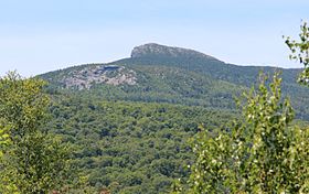
Camel's Hump, July 2012
|
|
| Highest point | |
| Elevation | 4,083 ft (1,244 m) NAVD 88 |
| Prominence | 1,860 ft (570 m) |
| Listing |
New England 4,000-footers New England Fifty Finest #46 |
| Coordinates | 44°19′10.37″N 72°53′10.78″W / 44.3195472°N 72.8863278°WCoordinates: 44°19′10.37″N 72°53′10.78″W / 44.3195472°N 72.8863278°W |
| Geography | |
| Location | Huntington / Duxbury, Vermont, U.S. |
| Parent range | Green Mountains |
| Geology | |
| Age of rock | 550 million years |
| Climbing | |
| Easiest route | Hiking trail |
| Designated | 1968 |
| Camel's Hump State Park | |
|---|---|
| Type | State park |
| Location | Camel's Hump Road Huntington, Vermont |
| Area | About 20,000 acres |
| Operated by | Vermont Department of Forests, Parks, and Recreation |
| Website | http://www.vtstateparks.com/htm/camelshump.htm |
Camel's Hump (alternatively Camels Hump) is Vermont's third-highest mountain and highest undeveloped peak. Because of its distinctive profile, it is perhaps the state's most recognized mountain, featured on the state quarter. It is part of the Green Mountain range. With its neighbor to the north, Mount Mansfield, it borders the notch that the Winooski River has carved through the ridgeline of the Green Mountains over eons. The hiking trails on Camel's Hump were among the first cut in the Long Trail system, and Camel's Hump remains a popular summit for through- and day-hiking. The mountain is part of Camel's Hump State Park.
Since Europeans first saw the mountain, probably on Samuel de Champlain's 1609 trip down Lake Champlain to the west, the mountain has had a number of names related to its distinctive shape. De Champlain named the mountain "Le Lion Couchant", a heraldic image which roughly translates as "The Resting Lion". Ira Allen later referred to the mountain as "Camel's Rump" on a map from 1798. It was not until 1830 that the name "Camel's Hump" came into usage. The Geographic Names Information System (GNIS) lists twelve variant names including Tah-wak-be-dee-ee-so wadso and Catamountain. While place names are determined by local usage the U.S. Board on Geographic Names (BGN) serves as a central authority in the United States concerning place names. Since its inception in 1890 the BGN has discouraged the use of the genitive apostrophe. Local usage is often at odds with this policy and so the name of this mountain is alternatively spelled with and without an apostrophe.
Camel's Hump is more notable for its shape than its height. Isolated from neighboring peaks by the Winooski Valley and glacial action, the mountain's conical silhouette is distinctive, if misleading. It has two "humps", with the southernmost being the higher, and a steep drop to the south as a result of a quarrying action of the ice passing over it. While it looks somewhat volcanic from the east and west, the movement of glacial ice created its current form and the National Park Service names the peak as "an exceptional illustration of the complex anticlinal deformation which formed the Green Mountains". The bedrock consists of phyllite, quartzite and schist.
...
Wikipedia
