Calvados (department)
| Calvados | |||
|---|---|---|---|
| Department | |||

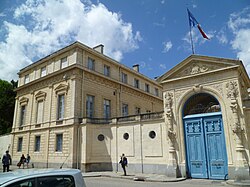
Prefecture building of the Calvados department, in Caen
|
|||
|
|||
 Location of Calvados in France |
|||
| Coordinates: 49°02′N 0°15′E / 49.033°N 0.250°ECoordinates: 49°02′N 0°15′E / 49.033°N 0.250°E | |||
| Country | France | ||
| Region | Normandy | ||
| Prefecture | Caen | ||
| Subprefectures |
Bayeux Lisieux Vire-Normandie |
||
| Government | |||
| • President of the General Council | Jean-Léonce Dupont (New Centre) | ||
| Area | |||
| • Total | 5,548 km2 (2,142 sq mi) | ||
| Population (2013) | |||
| • Total | 689,945 | ||
| • Rank | 34th | ||
| • Density | 120/km2 (320/sq mi) | ||
| Time zone | CET (UTC+1) | ||
| • Summer (DST) | CEST (UTC+2) | ||
| Department number | 14 | ||
| Arrondissements | 4 | ||
| Cantons | 25 | ||
| Communes | 621 | ||
| ^1 French Land Register data, which exclude estuaries, and lakes, ponds, and glaciers larger than 1 km2 | |||
Calvados (French pronunciation: [kal.va.dos]; English /ˈkælvədoʊs/) is a department in the Normandy region in northwestern France. It takes its name from a cluster of rocks off the English Channel coast.
Calvados is one of the original 83 departments created during the French Revolution on 4 March 1790. It was created from a part of the former province of Normandy. The name "Orne inférieure" was originally proposed for the department, but it was ultimately decided to call the area Calvados after a group of rocks off its coast.
One popular legend ascribes its etymology to the Salvador, a ship from the Spanish Armada that sank by the rocks near Arromanches-les-bains in 1588. It is more likely, however, that the name Calvados was derived from calva dorsa, meaning bare backs, in reference to two sparsely vegetated rocks off its shore.
After the allied victory at Waterloo the department was occupied by Prussian troops between June 1815 and November 1818.
On 6 June 1944, the Allied forces landed on the beaches of the Bay of the Seine in what became known as the Battle of Normandy.
...
Wikipedia


