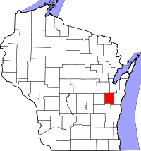
Calumet County
| Calumet County, Wisconsin | |
|---|---|

|
|
 Location in the U.S. state of Wisconsin |
|
 Wisconsin's location in the U.S. |
|
| Founded | 1850 |
| Seat | Chilton |
| Largest city | Chilton |
| Area | |
| • Total | 397 sq mi (1,028 km2) |
| • Land | 318 sq mi (824 km2) |
| • Water | 79 sq mi (205 km2), 20% |
| Population | |
| • (2010) | 48,971 |
| • Density | 154/sq mi (59/km²) |
| Congressional district | 8th |
| Time zone | Central: UTC-6/-5 |
| Website | www |
Calumet County is a county located in the U.S. state of Wisconsin. As of the 2010 census, the population was 48,971. The county seat is Chilton. The county was created in 1836 (then in the Wisconsin Territory) and organized in 1850.
Calumet County is included in the Appleton, WI Metropolitan Statistical Area as well as the Appleton-Oshkosh-Neenah, WI Combined Statistical Area.
The Holyland is partially located in southern Calumet County.
The county's name originated from the word calumet, the French name for the ceremonial pipes used by Native Americans in councils on the east shore of Lake Winnebago.
In the 1830s, the United States government relocated Native Americans from New York and New England to the southwest part of the county; these included the Brothertown Indians, Oneida Indians, and Indians. This was a second migration for the Brothertown and Stockbridge Indians, who had moved to New York after the American Revolutionary War. The Oneida shared land on their reservation with these peoples, who had been displaced by the years of colonization in New England, warfare and disease. Each of the three groups are federally recognized with reservations in Wisconsin.
...
Wikipedia
