Caledonia-Fairbanks
| Fairbank | |
|---|---|
| Neighbourhood | |

View of Fairbank Memorial Park, looking south.
|
|
 Vicinity |
|
| Location within Toronto | |
| Coordinates: 43°41′44″N 79°27′00″W / 43.69556°N 79.45000°WCoordinates: 43°41′44″N 79°27′00″W / 43.69556°N 79.45000°W | |
| Country |
|
| Province |
|
| City |
|
| Community | York |
| Established | 1891 (Postal village) |
| Changed Municipality | 1998 Toronto from York |
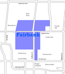
Fairbank is a neighbourhood in Toronto, Ontario, Canada. The area covers a large central portion of the former City of York, Ontario centered on the intersection of Dufferin Street and Eglinton Avenue West. Fairbank includes the neighbourhoods of Briar Hill–Belgravia (North of Eglinton Avenue West) and Caledonia–Fairbank (South of Eglinton Avenue West). The western border is the CNR lines. The northern and southern borders are the former borders of the City of York and the eastern border is Dufferin Street (Oakwood–Vaughan).
The area began at the Fairbank Postal Village at the intersection of Vaughan Road (an early settler's street crossing though farmland on the way to Vaughan Township) at Eglinton and Dufferin Street. The postal village name was derived from the Fairbank Farm owned by English settler Matthew Parsons (and named by his father-in-law Jacob Mackay).
St Hilda's Anglican church (St. Hilda's Retirement Residence, added in 1975) was built at the Fairbank intersection, although a cul-de-sac was later created at the northern end of Vaughan Road to simplify the Eglinton and Dufferin intersection when Eglinton Avenue began to develop as a commercial street with many mid-rise apartment buildings.
The neighbourhood has many rolling hills and steep, climbing streets. To the west, Prospect Cemetery separates Fairbank from development along the railway. Most of the neighbourhood as it exists today was planned in the interwar years (1920s & 1930s) with mostly small single family 2 and 1½ storey detached homes on north-south residential streets. Eglinton Ave. is organized into two BIAs: Fairbank Village and York-Eglinton. St. Clair Avenue to the south is organized into two BIAs: 'Corso Italia' and 'St. Clair Gardens'. The neighbour historically acts an extension of Corso Italia - having a heavy Italian influence, however is now heavily influenced and inhabited by Portuguese immigrants.
...
Wikipedia

