Caldwell, Texas
| Caldwell, Texas | |
|---|---|
| City | |

Historic Reeves-Womack House in Caldwell
|
|
| Nickname(s): The Kolache Capital of Texas, The Big Grape | |
| Motto: "Preparing for the Future with Respect for the Past" | |
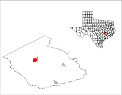
 Location of Caldwell in the state of Texas |
|
 |
|
| Coordinates: 30°31′43″N 96°42′1″W / 30.52861°N 96.70028°WCoordinates: 30°31′43″N 96°42′1″W / 30.52861°N 96.70028°W | |
| Country | United States |
| State | Texas |
| County | Burleson |
| Government | |
| • Mayor | Norris McManus |
| • City Administrator | Johnny Price |
| Area | |
| • Total | 3.9 sq mi (10.2 km2) |
| • Land | 3.9 sq mi (10.1 km2) |
| • Water | 0.04 sq mi (0.1 km2) |
| Elevation | 384 ft (117 m) |
| Population (2010) | |
| • Total | 4,104 |
| • Density | 1,053/sq mi (406.5/km2) |
| Time zone | CST (UTC-6) |
| • Summer (DST) | CDT (UTC-5) |
| ZIP code | 77836 |
| Area code(s) | 979 |
| FIPS code | 48-11836 |
| GNIS feature ID | 1353534 |
| Website | www |
Caldwell is a city in Burleson County, Texas, United States. The population was 4,104 at the 2010 census. It is the county seat of Burleson County. It is part of the Bryan-College Station metropolitan area.
Caldwell is the home of the Czech Heritage Museum, which is open to the public on Saturdays from 10 a.m. to 3 p.m. The annual Kolache Festival, a celebration of Czech heritage named for a type of pastry, is held in Caldwell the second weekend of September.
Caldwell is located northwest of the center of Burleson County at 30°31′43″N 96°42′1″W / 30.52861°N 96.70028°W (30.528580, -96.700350).Texas State Highway 21 passes through the center of the city, leading northeast 23 miles (37 km) to Bryan and southwest 50 miles (80 km) to Bastrop. Texas State Highway 36 bypasses the center of the city to the northeast, leading northwest 16 miles (26 km) to Milano and southeast 32 miles (51 km) to Brenham.
According to the United States Census Bureau, Caldwell has a total area of 3.9 square miles (10.2 km2), of which 0.03 square miles (0.07 km2), or 0.66%, is water.
As of the census of 2000, there were 3,449 people, 1,322 households, and 938 families residing in the city. The population density was 1,021.4 people per square mile (394.0/km²). There were 1,485 housing units at an average density of 439.8 per square mile (169.6/km²). The racial makeup of the city was 71.24% White, 12.64% African American, 0.17% Native American, 0.09% Asian, 13.71% from other races, and 2.15% from two or more races. Hispanic or Latino of any race were 22.96% of the population.
...
Wikipedia
