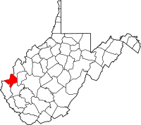
Cabell County, Virginia
| Cabell County, West Virginia | |
|---|---|

Cabell County Courthouse in Huntington
|
|
 Location in the U.S. state of West Virginia |
|
 West Virginia's location in the U.S. |
|
| Founded | January 2, 1809 |
| Named for | William H. Cabell |
| Seat | Huntington |
| Largest city | Huntington |
| Area | |
| • Total | 288 sq mi (746 km2) |
| • Land | 281 sq mi (728 km2) |
| • Water | 7.0 sq mi (18 km2), 2.4% |
| Population (est.) | |
| • (2017) | 94,958 |
| • Density | 346/sq mi (134/km2) |
| Congressional district | 3rd |
| Time zone | Eastern: UTC−5/−4 |
| Website | www |
Cabell County is a county in the U.S. state of West Virginia. As of the 2010 census, the population was 96,319, making it West Virginia's fourth-most populous county. Its county seat is Huntington. The county was organized in 1809 and named for William H. Cabell, the Governor of Virginia from 1805 to 1808.
Cabell County is part of the Huntington-Ashland, WV-KY-OH Metropolitan Statistical Area.
According to the U.S. Census Bureau, the county has an area of 288 square miles (750 km2), of which 281 square miles (730 km2) is land and 7.0 square miles (18 km2) (2.4%) is water.
As of the census of 2000, there were 96,784 people, 41,180 households, and 25,490 families residing in the county. The population density was 344 people per square mile (133/km²). There were 45,615 housing units at an average density of 162 per square mile (63/km²). The racial makeup of the county was 93.37% White, 4.29% Black or African American, 0.18% Native American, 0.77% Asian, 0.04% Pacific Islander, 0.20% from other races, and 1.14% from two or more races. 0.68% of the population were Hispanic or Latino of any race.
...
Wikipedia
