Burra Parish
|
Burra New South Wales |
|||||||||||||||
|---|---|---|---|---|---|---|---|---|---|---|---|---|---|---|---|

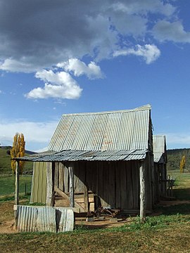
London Bridge Homestead, an early Burra residence now contained within the Googong Foreshores.
|
|||||||||||||||
| Coordinates | 35°33′39″S 149°13′13″E / 35.56083°S 149.22028°ECoordinates: 35°33′39″S 149°13′13″E / 35.56083°S 149.22028°E | ||||||||||||||
| Population | 794 (2016 census) | ||||||||||||||
| Postcode(s) | 2620 | ||||||||||||||
| Location |
|
||||||||||||||
| LGA(s) | Queanbeyan-Palerang Region | ||||||||||||||
| County | Murray | ||||||||||||||
| Parish | Burra | ||||||||||||||
| State electorate(s) | Monaro | ||||||||||||||
| Federal Division(s) | Eden-Monaro | ||||||||||||||
|
|||||||||||||||
Burra is an Australian district and parish of rural smallholdings lying 20 kilometres to the south of Queanbeyan, New South Wales in the Queanbeyan-Palerang Region. At the 2016 census, Burra had a population of 794 people.
The districts bounds have been defined as being the area to the south of the intersection of the Burra and Cooma Roads that contains the catchments of the Burra, Urila, Waterholes and Guises Creeks, and bounded to the East by the Queanbeyan River. The Burra Creek, whose headwaters are in the Tinderry Nature Reserve, flows through the centre of the Burra Valley to join the waters of the Queanbeyan River at the Googong Reservoir. Nearby small settlements include Royalla, Williamsdale and Michelago to the west and south. The Urila Valley is accessed from the Burra Valley and lies to the east. Burra is also a commutable distance from Australia's capital city Canberra.
It is also a parish of the County of Murray. The parish originally consisted of land between Guises Creek in the west, and Burra Creek in the east, encompassing land on both sides of Jerrabomberra Creek. A small part of this land was located to the west of the Queanbeyan-Cooma railway line and thus became part of the Australian Capital Territory in 1911.
The Ngarigo people originally inhabited Burra as part of their wider country lands extending south to the Australian Alps. The first European camp was called 'The Creek' although it soon became known amongst the early settlers as "The Burra", possibly from a local aboriginal word (for instance, the Ngarigo word "berra", meaning boomerang). The first grazing and clearing of the area began in the 1830-60s and farms in the burra valley were established at the Warm Corner, KT Park, Burra Station (the original 'creek' station), London Bridge and Lagoon. By the 1920s the local population had become large enough to support two competing cricket clubs, one at the Burra park, the other near Urila. Subdivision into smaller blocks began in the 1960s as Canberra's population expanded and has created the local regions such as those surrounding Candy Road, Badgery Road and Plumbers Road. Today the majority of the area has been subdivided in this way creating a population of 266 houses at the 2016 census.
...
Wikipedia

