Burnside, Pennsylvania
| Burnside, Pennsylvania | |
|---|---|
| Borough | |

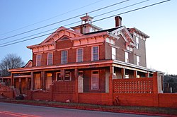
The Irvin-Patchin House on Main Street
|
|
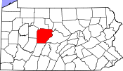
 Map showing Burnside in Clearfield County |
|
 Map showing Clearfield County in Pennsylvania |
|
| Pennsylvania | |
| Coordinates: 40°48′48″N 78°47′16″W / 40.81333°N 78.78778°WCoordinates: 40°48′48″N 78°47′16″W / 40.81333°N 78.78778°W | |
| Country | United States |
| State | Pennsylvania |
| County | Clearfield |
| Incorporated | 1874 |
| Government | |
| • Type | Borough Council |
| Area | |
| • Total | 1.73 sq mi (4.49 km2) |
| • Land | 1.68 sq mi (4.35 km2) |
| • Water | 0.05 sq mi (0.14 km2) |
| Elevation | 1,340 ft (410 m) |
| Population (2010) | |
| • Total | 234 |
| • Density | 139/sq mi (53.8/km2) |
| Time zone | Eastern (EST) (UTC-5) |
| • Summer (DST) | EDT (UTC-4) |
| ZIP code | 15721 |
| Area code(s) | 814 |
Burnside is a borough in Clearfield County, Pennsylvania, United States. The population was 234 at the 2010 census.
Burnside is located in southwestern Clearfield County at 40°48′48″N 78°47′16″W / 40.81333°N 78.78778°W (40.813203, -78.787645), along the West Branch Susquehanna River. It is bordered on the north, east, and south by Burnside Township and on the west by Indiana County.
U.S. Route 219 passes through the borough, leading north 37 miles (60 km) to DuBois and south 26 miles (42 km) to Ebensburg.
According to the United States Census Bureau, Burnside has a total area of 1.73 square miles (4.49 km2), of which 1.68 square miles (4.35 km2) is land and 0.054 square miles (0.14 km2), or 3.16%, is water.
As of the census of 2000, there were 283 people, 102 households, and 79 families residing in the borough. The population density was 168.8 people per square mile (65.0/km²). There were 115 housing units at an average density of 68.6 per square mile (26.4/km²). The racial makeup of the borough was 100.00% White.
...
Wikipedia

