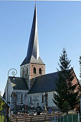
Bures-en-Bray
| Bures-en-Bray | |
|---|---|
 |
|
| Coordinates: 49°46′44″N 1°20′09″E / 49.7789°N 1.3358°ECoordinates: 49°46′44″N 1°20′09″E / 49.7789°N 1.3358°E | |
| Country | France |
| Region | Normandy |
| Department | Seine-Maritime |
| Arrondissement | Dieppe |
| Canton | Neufchâtel-en-Bray |
| Intercommunality | Londinières |
| Government | |
| • Mayor (2008–2014) | Jacky Lévêque |
| Area1 | 10.99 km2 (4.24 sq mi) |
| Population (2006)2 | 313 |
| • Density | 28/km2 (74/sq mi) |
| Time zone | CET (UTC+1) |
| • Summer (DST) | CEST (UTC+2) |
| INSEE/Postal code | 76148 /76660 |
| Elevation | 47–201 m (154–659 ft) (avg. 83 m or 272 ft) |
|
1 French Land Register data, which excludes lakes, ponds, glaciers > 1 km² (0.386 sq mi or 247 acres) and river estuaries. 2Population without double counting: residents of multiple communes (e.g., students and military personnel) only counted once. |
|
1 French Land Register data, which excludes lakes, ponds, glaciers > 1 km² (0.386 sq mi or 247 acres) and river estuaries.
Bures-en-Bray is a commune in the Seine-Maritime department in the Normandy region in northern France.
A farming village situated in the Pays de Bray, 20 miles (32 km) southeast of Dieppe, at the junction of the D1 with the D114 and D12 roads. The Béthune River flows through the middle of the village.
...
Wikipedia


