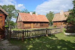
Bunge, Gotland
| Bunge | |
|---|---|

One of the farms at Bunge Museum
|
|
| Coordinates: 57°51′13″N 19°01′24″E / 57.85361°N 19.02333°ECoordinates: 57°51′13″N 19°01′24″E / 57.85361°N 19.02333°E | |
| Country | Sweden |
| Province | Gotland |
| County | Gotland County |
| Municipality | Gotland Municipality |
| Area | |
| • Total | 34 km2 (13 sq mi) |
| Population (2014) | |
| • Total | 886 |
| Time zone | CET (UTC+1) |
| • Summer (DST) | CEST (UTC+2) |
Bunge is a settlement on the Swedish island of Gotland. It is situated in the northernmost part of Gotland, southwest of Fårösund. Formerly a socken, on 1 January 2016, it was reconstituted into the administrative area Bunge District.
Bunge is the name of the socken, now district. It is also the name of the small village surrounding the medieval Bunge Church, sometimes referred to as Bunge kyrkby. It is situated on the north coast of Gotland.
Bunge has a private airfield, the Bunge Airbase. The hangar and the airfield are listed buildings.
Gotland's (and one of Sweden's) most noted open-air museum is the Bunge museum. The museum has farms from three centuries (17th, 18th and 19th) and is also very active in practical old industry such as recreating tar kilns and charcoal piles.
The wall at Bunge church.
The village pond at Bunge museum.
Wind mill at Bunge Museum.
The Bunge Museum.
Ruin behind Bunge Church.
Bunge airfield.
...
Wikipedia

