Bullitt County, Kentucky
| Bullitt County, Kentucky | |
|---|---|

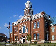
Bullitt County Courthouse in Shepherdsville
|
|
 Location in the U.S. state of Kentucky |
|
 Kentucky's location in the U.S. |
|
| Founded | 1796 |
| Named for | Alexander Scott Bullitt |
| Seat | Shepherdsville |
| Largest city | Shepherdsville |
| Area | |
| • Total | 300 sq mi (777 km2) |
| • Land | 297 sq mi (769 km2) |
| • Water | 3.2 sq mi (8 km2), 1.1% |
| Population (est.) | |
| • (2015) | 78,702 |
| • Density | 250/sq mi (97/km²) |
| Congressional district | 2nd |
| Time zone | Eastern: UTC-5/-4 |
| Website | bullittcounty |
Bullitt County is a county in the U.S. state of Kentucky located in the far western Bluegrass region known as the Knobs. As of the 2010 census, the population was 74,319. The county seat is Shepherdsville. The county was founded in 1796.
Located just south of the city of Louisville, Bullitt County is included in the Louisville/Jefferson County, KY-IN Metropolitan Statistical Area, commonly known as Kentuckiana.
The western fifth of the county (40,000 acres (160 km2)) is part of the United States Army post of Fort Knox and is reserved for military training.
The first inhabitants of the land that would become Bullitt County were the Paleo-Indians who entered North America approximately 11,500 to 10,000 years BP. These people, whose ancestors can be traced back to Eastern and Central Asia, were nomadic. They were hunters and gatherers whose remains have been discovered near the area's mineral springs or salt licks, where big game such as the mammoth, bison and ground sloth once gathered. Native Americans were their descendants, including the Shawnee people, who probably considered this region part of their homeland and certainly valued it as a hunting ground.
...
Wikipedia
