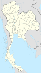
Buketa
|
Buketa บูเก๊ะตา |
|
|---|---|
| Location in Thailand | |
| Coordinates: 5°50′36″N 101°52′53″E / 5.84333°N 101.88139°E | |
| Country |
|
| Province | Narathiwat |
| District | Amphoe Waeng |
| Population (2007) | |
| • Total | 4,079 |
Buketa (Thai: บูเก๊ะตา) is a subdistrict municipality (thesaban tambon) in Waeng district, Narathiwat Province, Thailand. It covers an area of 7.04 km2 (2.72 sq mi) of the subdistrict Lochut, and as of 2007 has a population of 4,079. The municipality lies west of the Kolok River.
The municipality was created as a sanitary district (sukhaphiban) in 1993. Like all sanitary districts it was upgraded to a subdistrict municipality in 1999.
A crossing on the Malaysia-Thailand border to the neighboring Malaysian town of Bukit Bunga in Kelantan state was opened in December 2007, crossing the Kolok River with the Bukit Bunga-Ban Buketa Bridge.
Coordinates: 5°50′36″N 101°52′53″E / 5.843304°N 101.88136°E
...
Wikipedia

