Bucks County
| Bucks County, Pennsylvania | |
|---|---|

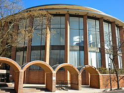
Bucks County Courthouse
|
|
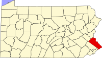
 Location in the U.S. state of Pennsylvania |
|
 Pennsylvania's location in the U.S. |
|
| Founded | November 1682 |
| Named for | Buckinghamshire |
| Seat | Doylestown |
| Largest township | Bensalem |
| Area | |
| • Total | 622 sq mi (1,611 km2) |
| • Land | 604 sq mi (1,564 km2) |
| • Water | 18 sq mi (47 km2), 2.8% |
| Population (est.) | |
| • (2015) | 627,367 |
| • Density | 1,039/sq mi (401/km²) |
| Congressional district | 8th |
| Time zone | Eastern: UTC-5/-4 |
| Website | www |
| Footnotes: | |
| Designated | October 29, 1982 |
Bucks County is a county located in the Commonwealth of Pennsylvania. As of the 2010 census, the population was 625,249, making it the fourth-most populous county in Pennsylvania and the 98th-most populous county in the United States. The county seat is Doylestown. The county is named after the English county of Buckinghamshire.
Bucks County is included in the Philadelphia–Camden–Wilmington, PA–NJ–DE–MD Metropolitan Statistical Area, more commonly known as the "Delaware Valley". It is located immediately northeast of Philadelphia and forms part of the southern tip of the eastern state border.
Bucks County is one of the three original counties created by colonial proprietor William Penn in 1682. Penn named the county after Buckinghamshire, the county where he lived in England. He built a country estate called Pennsbury Manor in Falls Township, Bucks County.
Some places in Bucks County were named after locations in Buckinghamshire, including Buckingham Township, named after the county town of Buckinghamshire; Chalfont, named after Chalfont St Giles, the parish home of William Penn's first wife and the location of the Jordans Quaker Meeting House, where Penn is buried; Solebury Township, named after Soulbury, England; and Wycombe, named after the town of High Wycombe.
...
Wikipedia
