Chalfont St Giles
| Chalfont St Giles | |
|---|---|
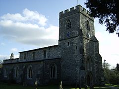
 St Giles' parish church |
|
| Chalfont St Giles shown within Buckinghamshire | |
| Population | 5,925 (2011 Census) |
| OS grid reference | SU9893 |
| Civil parish |
|
| District | |
| Shire county | |
| Region | |
| Country | England |
| Sovereign state | United Kingdom |
| Post town | Chalfont St. Giles |
| Postcode district | HP8 |
| Dialling code | 01494 |
| Police | Thames Valley |
| Fire | Buckinghamshire |
| Ambulance | South Central |
| EU Parliament | South East England |
| UK Parliament | |
| Website | The Chalfont St Giles village website |
Chalfont St Giles is a village and civil parish within Chiltern district in south east Buckinghamshire, England, on the edge of the Chilterns, 25 miles (40 km) from London, and near Seer Green, Jordans, Chalfont St Peter, Little Chalfont and Amersham.
Chalfont means chalk spring, in reference to the water carrying capacities of the local terrain. The village has a duck pond that is fed by the River Misbourne.
The Church of England parish church of Saint Giles is of Norman architecture and dates from the 12th century. The church contains many notable features, including a lychgate, wall paintings from the early 14th century, and iron cannon balls embedded in the stone, believed to have been fired by Oliver Cromwell's troops when camped in the neighbouring field after the Battle of Aylesbury. The Bishop Francis Hare is buried there.
In the Domesday Book in 1086 Chalfont St Giles and Chalfont St Peter are listed as separate Manors with different owners, called 'Celfunte'. They were separate holdings before the Norman Conquest.
Like most other rural parishes it managed its civil affairs through the vestry until the Local Government Act 1894 required all parishes of over 300 people to have a Parish council independent of the Church.
...
Wikipedia

