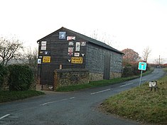
Buckland Common
| Buckland Common | |
|---|---|
 Nethercott's Barn |
|
| Buckland Common shown within Buckinghamshire | |
| Population | 8 |
| OS grid reference | SP909069 |
| • London | 29 miles (47 km) |
| Civil parish | |
| District | |
| Shire county | |
| Region | |
| Country | England |
| Sovereign state | United Kingdom |
| Post town | Tring |
| Postcode district | HP23 |
| Dialling code | 01494 |
| EU Parliament | South East England |
| UK Parliament | |
| Website | cholesbury-cum-st leonards |
Buckland Common is a hamlet in Buckinghamshire, England. It is located in the Chiltern Hills, 4 miles (6.4 km) east of Wendover and the same distance south of Tring in Hertfordshire with which it shares a boundary. The northern end of the settlement is delineated by a short section of Grim's Ditch. It is in the civil parish of Cholesbury-cum-St Leonards.
Evidence of prehistoric settlement has been found in the form of a Palaeolithic handaxe found on a ploughed field'. A section of the Chiltern Grim's Ditch linear earthwork, which is believed to have been constructed during the Iron Age, marks the northern boundary of Buckland Common. Though what remains is eroded and only a poorly preserved ditch and bank are still visible.
The area today called Buckland Common had in Edward the Confessor's time been the southern and upland part of the manor of Buckland which was under the control of the see of Dorchester. Following the Norman Invasion, Buckland had become incorporated into the estates owned by the Church of Lincoln. This upland area would have originally comprised impenetrable scrub woodland but gradual clearance created pasture land which provided advantageous grazing for cattle and sheep. Perhaps this location was chosen on account of it being more sheltered lying as it does in a slight depression in comparison to the surrounding land. It is believed the first permanent settlement began in the 16th century, around the time when Henry VIII seized the lands from the Earl of Warwick in 1522.
...
Wikipedia

