Buchanan, New York
| Buchanan, New York | |
|---|---|
| Village | |
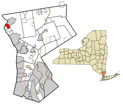
 Location of Buchanan, New York |
|
| Coordinates: 41°15′39″N 73°56′30″W / 41.26083°N 73.94167°W | |
| Country | United States |
| State | New York |
| County | Westchester |
| Government | |
| • Mayor | Theresa Knickerbocker (D) |
| • Board of Trustees |
Members
|
| Area | |
| • Total | 1.7 sq mi (4.4 km2) |
| • Land | 1.4 sq mi (3.6 km2) |
| • Water | 0.3 sq mi (0.8 km2) |
| Elevation | 39 ft (12 m) |
| Population (2010) | |
| • Total | 2,230 |
| • Density | 1,300/sq mi (510/km2) |
| • Demonym | Buchananite |
| Time zone | Eastern (EST) (UTC-5) |
| • Summer (DST) | EDT (UTC-4) |
| ZIP code | 10511 |
| Area code(s) | 914 |
| FIPS code | 36-10341 |
| GNIS feature ID | 0945006 |
| Website | http://www.villageofbuchanan.com |
Buchanan is a village located in the town of Cortlandt in Westchester County, New York. The population was 2,230 as of the 2010 census.
The Indian Point nuclear power facility is located in Buchanan. The 2000 Rockefeller Center Christmas Tree also came from Buchanan.
Buchanan is located at 41°15′39″N 73°56′30″W / 41.26083°N 73.94167°WCoordinates: 41°15′39″N 73°56′30″W / 41.26083°N 73.94167°W.
According to the United States Census Bureau, the village has a total area of 1.7 square miles (4.4 km2), of which 1.4 square miles (3.6 km2) are land and 0.3 square miles (0.78 km2), or 17.86%, is water.
As of the census of 2000, there were 2,189 people, 814 households, and 609 families residing in the village. The population density was 1,579.3 people per square mile (608.0/km²). There were 912 housing units at an average density of 658.0 per square mile (253.3/km²). The racial makeup of the village was 96.21% White, 0.69% African American, 0.18% Native American, 1.19% Asian, 0.78% from other races, and 0.96% from two or more races. Hispanic or Latino of any race were 3.47% of the population.
...
Wikipedia
