Bryansk Oblast
|
Bryansk Oblast Брянская область (Russian) |
|||
|---|---|---|---|
| — Oblast — | |||
|
|||
|
|
|||
|
|||
|
|
|||
| Political status | |||
| Country | Russia | ||
| Federal district | Central | ||
| Economic region | Central | ||
| Established | July 5, 1944 | ||
| Administrative center | Bryansk | ||
| Government (as of November 2014) | |||
| • Governor (acting) | Alexander Bogomaz | ||
| • Legislature | Oblast Duma | ||
| Statistics | |||
| Area (as of the 2002 Census) | |||
| • Total | 34,900 km2 (13,500 sq mi) | ||
| Area rank | 62nd | ||
| Population (2010 Census) | |||
| • Total | 1,278,217 | ||
| • Rank | 38th | ||
| • Density | 36.63/km2 (94.9/sq mi) | ||
| • Urban | 69.1% | ||
| • Rural | 30.9% | ||
| Population (January 2015 est.) | |||
| • Total | 1,232,940 | ||
| Time zone(s) | MSK (UTC+03:00) | ||
| ISO 3166-2 | RU-BRY | ||
| License plates | 32 | ||
| Official languages | Russian | ||
| Official website | |||
|
|
|---|
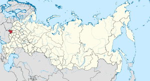
Bryansk Oblast (Russian: Бря́нская о́бласть, Bryanskaya oblast) is a federal subject of Russia (an oblast). Its administrative center is the city of Bryansk. As of the 2010 Census, its population was 1,278,217.
Bryansk Oblast lies in western European Russia in the central to western parts of the East European Plain, on the divide between the Desna and Volga basins. The oblast borders with Smolensk Oblast in the north, Kaluga Oblast in the northeast, Oryol Oblast in the east, Kursk Oblast in the southeast, Chernihiv and Sumy Oblasts of Ukraine in the south, and with Gomel and Mogilev Oblasts of Belarus in the west.
The relief is a typical East European Plain landscape, with alternating rolling hills and shallow lowlands, although lowlands dominate in the western and central parts. A total of 125 rivers flow through Bryansk Oblast, with the longest one, at 1,187 kilometers (738 mi), being the Desna (a tributary of the Dnieper). Other major rivers include the Bolva, Navlya, Nerussa, Sudost (all tributaries of the Desna), Besed, and Iput. There are forty-nine major lakes, with Lake Kozhany being the largest.
...
Wikipedia


