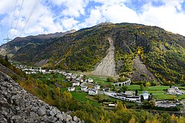
Brusio
| Brusio | ||
|---|---|---|
 |
||
|
||
| Coordinates: 46°15′N 10°8′E / 46.250°N 10.133°ECoordinates: 46°15′N 10°8′E / 46.250°N 10.133°E | ||
| Country | Switzerland | |
| Canton | Graubünden | |
| District | Bernina | |
| Area | ||
| • Total | 46.29 km2 (17.87 sq mi) | |
| Elevation | 780 m (2,560 ft) | |
| Population (Dec 2015) | ||
| • Total | 1,106 | |
| • Density | 24/km2 (62/sq mi) | |
| Postal code | 7743 | |
| SFOS number | 3551 | |
| Localities | Viano, Cavaione, Campocologno, Campascio, Miralago, Zalende | |
| Surrounded by | Bianzone (IT-SO), Chiuro (IT-SO), Grosotto (IT-SO), Poschiavo, Teglio (IT-SO), Tirano (IT-SO), Vervio (IT-SO), Villa di Tirano (IT-SO) | |
| Website |
www SFSO statistics |
|
Brusio is a municipality in the Bernina Region in the canton of Graubünden in Switzerland.
Brusio is first mentioned in 1106 as Bruse. It was first mentioned as Brusio in 1212. Previously it was known as Romansh: Brüsch and German: Brüs.
The monastery of San Romerio (earlier, San Remigio) was founded above the Val Poschiavo before 1055. Soon there after the village of Brusio was settled on the valley floor below the monastery. The monastery influenced this early stage of settlement and growth in the village. By 1212 it was an independent municipality with its own dean or senior pastor who represented the municipality's interests. In the 13th Century, the entire Val Poschiavo became part of the fief of the Bishop of Chur. During the 14th Century, Brusio was part of the practically (but not officially) independent municipality of Poschiavo. Around 1498, Poschiavo (with Brusio) joined the League of God's House and by extension, the Three Leagues. During the conquest of the Valtellina valley by the Three Leagues, the hamlets of Campocologno (1518) and Zalende (1526) were founded. In 1610 Brusio tried to leave the municipality of Poschiavo, but it wasn't until 1851 that they were successful. In 1863, the previously Italian, side valley of Saiento and the hamlet of Cavajone joined Brusio and became Swiss.
Brusio has an area, as of 2006[update], of 46.3 km2 (17.9 sq mi). Of this area, 16.6% is used for agricultural purposes, while 54.1% is forested. Of the rest of the land, 2.3% is settled (buildings or roads) and the remainder (27%) is non-productive (rivers, glaciers or mountains).
...
Wikipedia


