Brule, Wisconsin
| Brule, Wisconsin | |
|---|---|
| Town | |
| Motto: "Home to the River of Presidents" | |
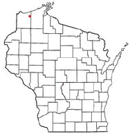
 Location of Brule, Wisconsin |
|
| Coordinates: 46°33′58″N 91°35′39″W / 46.56611°N 91.59417°W | |
| Country | United States |
| State | Wisconsin |
| County | Douglas |
| Area | |
| • Total | 55.9 sq mi (144.7 km2) |
| • Land | 55.7 sq mi (144.3 km2) |
| • Water | 0.2 sq mi (0.5 km2) |
| Elevation | 1,093 ft (333 m) |
| Population (2000) | |
| • Total | 591 |
| • Density | 10.6/sq mi (4.1/km2) |
| Time zone | Central (CST) (UTC-6) |
| • Summer (DST) | CDT (UTC-5) |
| ZIP code | 54820 |
| Area code(s) | 715 and 534 |
| FIPS code | 55-10575 |
| GNIS feature ID | 1582879 |
| Website | Town of Brule Wisconsin |
Brule is a town in Douglas County, Wisconsin, United States. The population was 591 at the 2000 census. The town takes its name from the nearby Bois Brule River, which flows north into Lake Superior. The census-designated place of Brule and unincorporated communities of Bellwood, Waino, and Winneboujou are located in the town of Brule.
The Town of Brule was founded on November 13, 1886.
The Brule River is one of the preeminent trout streams in North America, with abundant native and migratory steelhead, brown, and brook trout. Located near the primary trout spawning bed for western Lake Superior, Brule is a destination for serious fly fishermen from the around the world.
Four United States presidents, Calvin Coolidge, Herbert Hoover, Harry Truman, and Dwight Eisenhower, have summered near Brule in some of the many Adirondack-style lodges erected by prominent families from Minneapolis and Milwaukee. James Jesus Angleton, famed counterintelligence spy with the CIA, had a home on the river.
In 1899, Professor Ulysses Sherman Grant, of Northwestern University, inspected the Brule, Wisconsin area for ancient copper deposits.
According to the United States Census Bureau, the town has a total area of 55.9 square miles (144.7 km²), of which, 55.7 square miles (144.3 km²) of it is land and 0.2 square miles (0.5 km²) of it (0.32%) is water.
...
Wikipedia
