Bruckner Boulevard
| Bruckner Expressway | |
|---|---|

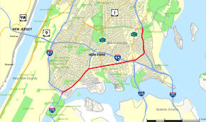
Map of the Bronx in New York City with Bruckner Expressway highlighted in red
|
|
| Route information | |
| Maintained by NYSDOT | |
| Length: | 7.02 mi (11.30 km) |
| Component highways: |
|
| Major junctions | |
| South end: |
|
|
|
|
| North end: |
|
| Highway system | |
The Bruckner Expressway is a freeway in the borough of the Bronx in New York City. It carries Interstate 278 (I-278) and I-95 (and formerly I-878) from the Triborough Bridge to the south end of the New England Thruway at the Pelham Parkway interchange. The highway follows a mostly northeast–southwest alignment through the southern portion of the borough, loosely paralleling the course of the East River. It connects to several major freeways including the Bronx River Parkway, and at the Bruckner Interchange, it connects to the Cross Bronx Expressway, the Whitestone Expressway, and the Hutchinson River Parkway.
The expressway begins at the northern approach to the Triborough Bridge, where I-278 meets the southern end of I-87, here known as the Major Deegan Expressway. It heads to the northeast as an elevated highway, carrying the I-278 designation through the South Bronx. After 2 miles (3.2 km), the Bruckner Expressway meets the short Sheridan Expressway (I-895) and turns eastward to cross the Bronx River into the Soundview neighborhood. Here, the highway connects to the Bronx River Parkway at an interchange one block north of that road's official southern terminus. The Bruckner Expressway remains I-278 into the adjacent neighborhood of Castle Hill, where I-278 enters the west half of the complicated Bruckner Interchange and I-95 transitions from the Cross Bronx Expressway to the Bruckner.
...
Wikipedia


