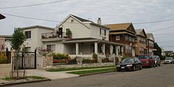
Castle Hill, Bronx
| Castle Hill | |
|---|---|
| Neighborhood of The Bronx | |

Quimby Avenue east of Castle Hill Avenue
|
|
| Location in New York City | |
| Coordinates: 40°49′07″N 73°50′59″W / 40.8186111°N 73.8497222°WCoordinates: 40°49′07″N 73°50′59″W / 40.8186111°N 73.8497222°W | |
| Country |
|
| State |
|
| City |
|
| Borough |
|
| Area | |
| • Total | 1.24 km2 (0.478 sq mi) |
| Population (2011) | |
| • Total | 8,079 |
| • Density | 6,500/km2 (17,000/sq mi) |
| Economics | |
| • Median income | $36,258 |
| ZIP codes | 10473 |
| Area code | 718, 347, 646 |
Castle Hill is primarily a residential neighborhood geographically located in the South Central section of the borough of the Bronx in New York City. The neighborhood is part of Bronx Community Board 9. Its boundaries, starting from the North and moving clockwise are: Waterbury and Westchester Avenues to the North, Westchester Creek to the east, the East River to the South, and White Plains Road to the West. Castle Hill Avenue runs from East Tremont Avenue in the north to Castle Hill Park in the south. ZIP codes include 10473. The area is patrolled by the NYPD's 43rd Precinct located at 900 Fteley Avenue. New York City Housing Authority (NYCHA) property in the area is patrolled by P.S.A. 8 at 2794 Randall Avenue.
Castle Hill is a high density, urban neighborhood. The area has a relatively diverse population; primarily consisting of African Americans, and Latin Americans, most predominantly Puerto Ricans (Castle Hill has one of the highest concentrations of Puerto Ricans in all of New York City). Like most neighborhoods in New York City the vast majority of households are renter occupied. There is significant income diversity on a block by block basis.
Castle Hill is dominated by multi-unit, 2 and 3 story homes and apartment buildings. In the 1990s and 2000s, construction of modern 2 and 3 unit row-houses and apartment buildings have increased the percentage of owners versus renters. There is also a slither of industry located along the Hutchinson River and Zerega Avenue. The area gradually comes to peak elevation along Castle Hill Avenue. The Castle Hill Avenue Business Improvement District was started with the assistance of Councilwoman Annabel Palma and James Vacca in June 2012.
Relatively undeveloped, the neighborhood began sprouting along the now defunct Castle Hill Avenue street-car system. Later, the neighborhood became more dense surrounding the construction of the Westchester Avenue Elevated. Castle Hill soon became home to many European immigrants looking for an alternative to the overpopulated immigrant communities found in Lower Manhattan. Traditionally an urban working-class neighborhood, an influx of lower-income earners and Latin American migrants beginning mid century diversified the income profile. Like most neighborhoods in NYC, the area went through a period of decay beginning in the 1950s and 1960s with a flight of moderate-income earners. The most severe flight occurred in the areas surrounding the Castle Hill Houses, a massive low-income public housing development. Since the late 1980s, and particularly since the 2000s, significant renewal has taken place. Many new residential and mixed use properties have been constructed and formally abandoned properties rehabilitated. For example, a New York City project to change the water pipes throughout the neighborhood has rejuvenated the area by rebuilding all sidewalks and renewing the asphalt in all of the streets.
...
Wikipedia


