Brownsville Township, Fayette County, Pennsylvania
| Brownsville Township | |
|---|---|
| Township | |

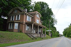
Scene along the National Road
|
|
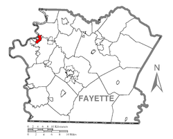
 Location of Brownsville Township in Fayette County |
|
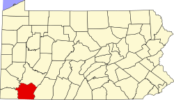
 Location of Fayette County in Pennsylvania |
|
| Country | United States |
| State | Pennsylvania |
| County | Fayette |
| Area | |
| • Total | 1.55 sq mi (4.0 km2) |
| • Land | 1.50 sq mi (3.9 km2) |
| • Water | 0.05 sq mi (0.1 km2) |
| Population (2010) | |
| • Total | 683 |
| • Density | 454.7/sq mi (175.6/km2) |
| Time zone | EST (UTC-4) |
| • Summer (DST) | EDT (UTC-5) |
| Area code(s) | 724 |
| Website | www |
Brownsville Township is a township in Fayette County, Pennsylvania, United States. The population was 683 at the 2010 census, down from 769 at the 2000 census. It is served by the Brownsville School District.
The township contains the populated places of Knoxville and Century.
Brownsville Township is in northwestern Fayette County; it is bordered to the west by the borough of Brownsville, to the southwest by Luzerne Township, to the southeast by Redstone Township, and to the northeast by Jefferson Township. On the northwest, across the Monongahela River, is the borough of West Brownsville in Washington County. Dunlap Creek forms the boundary with Luzerne Township and part of the boundary with Brownsville borough, while Redstone Creek forms the boundary with Jefferson Township; both creeks are tributaries of the Monongahela.
U.S. Route 40 crosses the township, leading northwest into Brownsville borough and southeast to Uniontown, the Fayette County seat. Downtown Pittsburgh is 40 miles (64 km) to the north.
According to the United States Census Bureau, the township has a total area of 1.55 square miles (4.01 km2), of which 1.50 square miles (3.89 km2) is land and 0.05 square miles (0.12 km2), or 2.91%, is water.
...
Wikipedia
