Broquiès
| Broquiès | ||
|---|---|---|

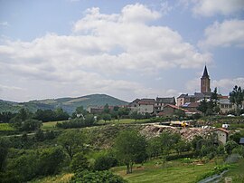
A general view of Broquiès
|
||
|
||
| Coordinates: 44°00′21″N 2°41′47″E / 44.0058°N 2.6964°ECoordinates: 44°00′21″N 2°41′47″E / 44.0058°N 2.6964°E | ||
| Country | France | |
| Region | Occitanie | |
| Department | Aveyron | |
| Arrondissement | Millau | |
| Canton | Saint-Rome-de-Tarn | |
| Government | ||
| • Mayor (2008–2014) | Bernard Brengues | |
| Area1 | 37.99 km2 (14.67 sq mi) | |
| Population (2008)2 | 644 | |
| • Density | 17/km2 (44/sq mi) | |
| Time zone | CET (UTC+1) | |
| • Summer (DST) | CEST (UTC+2) | |
| INSEE/Postal code | 12037 /12480 | |
| Elevation | 243–738 m (797–2,421 ft) (avg. 367 m or 1,204 ft) |
|
|
1 French Land Register data, which excludes lakes, ponds, glaciers > 1 km² (0.386 sq mi or 247 acres) and river estuaries. 2Population without double counting: residents of multiple communes (e.g., students and military personnel) only counted once. |
||
1 French Land Register data, which excludes lakes, ponds, glaciers > 1 km² (0.386 sq mi or 247 acres) and river estuaries.
Broquiès is a commune in the Aveyron department in southern France.
The commune is in the Raspes de Tarn; on both banks of the River Tarn The village is on the north bank where the land rises steeply from the Tarn River (243 metres (797 ft)) to the Lévézou plateau (600 metres (2,000 ft)). On each side of the village are streams that have cut deep valley. An strategically important road from Saint-Izaire and Saint-Affrique crosses the Tarn at le Navech, and uses the valley to the east to zig-zag upwards through Vieux Broquies to the promontory(350 metres (1,150 ft)- 400 metres (1,300 ft)) where the main village is located. Here the road heads along the valley side to Rodez, Le Truel and Villefranche-de-Panat. On the south bank the Dourdou de Camarès flows into the Tarn.
The crossing point at le Navech was served from medieavl times by a ferry. The first bridge was built in 1865. In 1875 it washed away by 'une grande crue' and was rebuilt. Again in 1982 the centre arches were breached by the 'crues' and the bridge rebuilt.
The La Jourdanie (power station) is on the River Tarn upstream of the Pont de Navech. Two Kaplan turbines and two helical turbines generate 18MW. The dam is 145m long and 17m high.
There was an artistic neolithic population in the area (3000BC). The Menhir de la Coste, now on display in the Fenaille Museum in Rodez occurred to the north of the commune adjacent to the ancient road (D25). It has been replaced by a replica. By 1000BC the area was occupied by iron age Celts called the 'broccos'. The Carolingians wrote of an incident at Broquiès fixing the date of the foundation of the village to around 800 AD.
...
Wikipedia


