Broomall, Pennsylvania
| Broomall, Pennsylvania (The 008) | |
| Census-designated place | |
| Country | United States |
|---|---|
| State | Pennsylvania |
| County | Delaware |
| Township | Marple |
| Elevation | 351 ft (107.0 m) |
| Coordinates | 39°58′18″N 75°21′17″W / 39.97167°N 75.35472°WCoordinates: 39°58′18″N 75°21′17″W / 39.97167°N 75.35472°W |
| Area | 2.9 sq mi (7.5 km2) |
| - land | 2.9 sq mi (8 km2) |
| - water | 0.0 sq mi (0 km2), 0% |
| Population | 10,789 (2010) |
| Density | 3,732.9/sq mi (1,441.3/km2) |
| Timezone | EST (UTC-5) |
| - summer (DST) | EDT (UTC-4) |
| ZIP code | 19008 |
| Area code | 610 and 484 |
| FIPS code | 42-09248 |
| GNIS feature ID | 1170351 |
|
Location in Delaware County and the state of Pennsylvania.
|
|
Broomall is a census-designated place (CDP) in Delaware County, Pennsylvania, United States. The population was 10,789 at the 2010 census.
The community was a crossroads community renamed for the post office established to honor John Martin Broomall, a 19th-century U.S. congressman from the area.
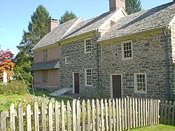
The Thomas Massey House is listed on the National Register of Historic Places.
Broomall is located in northeastern Delaware County at 39°58′18″N 75°21′17″W / 39.97167°N 75.35472°W (39.971561, −75.354674). It is in the eastern part of Marple Township and is bordered to the east by Darby Creek and to the north by Pennsylvania Route 3 (West Chester Pike). Pennsylvania Route 320 (Sproul Road) is the main north-south road in the community. Broomall is 10 miles (16 km) west of Center City Philadelphia.
According to the United States Census Bureau, the CDP has a total area of 2.9 square miles (7.5 km2), all of it land.
...
Wikipedia


