Marple Township, Delaware County, Pennsylvania
| Marple Township | ||
| Township | ||
|
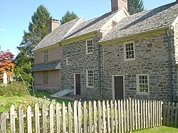
Seventeenth-century Thomas Massey House on Lawrence Road
|
||
|
||
| Country | United States | |
|---|---|---|
| State | Pennsylvania | |
| County | Delaware | |
| Elevation | 361 ft (110.0 m) | |
| Coordinates | 39°58′30″N 75°21′29″W / 39.97500°N 75.35806°WCoordinates: 39°58′30″N 75°21′29″W / 39.97500°N 75.35806°W | |
| Area | 10.5 sq mi (27.2 km2) | |
| - land | 10.2 sq mi (26 km2) | |
| - water | 0.3 sq mi (1 km2), 2.86% | |
| Population | 23,743 (2015) | |
| Density | 2,326.1/sq mi (898.1/km2) | |
| Timezone | EST (UTC-5) | |
| - summer (DST) | EDT (UTC-4) | |
| Area code | 610 | |
|
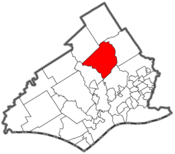
Location of Marple Township in Delaware County
|
||
|
Website: www |
||
Marple Township is a township in Delaware County, Pennsylvania, United States. The population was 23,743 at 2015. ZIP codes include mainly 19008, but also partially 19064 and 19063.
The Delaware County area was first settled by Quakers who came to Pennsylvania by the Delaware River on September 29, 1683. The ship they used was called the Endeavor. Marple Township was originally settled in 1684 and was recognized as a township in the same year. The original spelling of the township was Marpool, most likely named after the village of Marpoole in Cheshire, England.
One of the settlers that arrived on the Endeavor was Thomas Massey. He obtained a 300-acre plantation in the township from William Penn. The house he built on the land is still preserved today, as well as some of its surrounding gardens.
In 1948 Marple County gets its first police station. Before, there was no local branch and no patrols of the police and only a countiesheriff. Crimes were mostly settled between victims and perpetrators themselves.
Marple became a first class township in 1961.
According to the United States Census Bureau, the township has a total area of 10.5 square miles (27.2 km²), of which, 10.2 square miles (26.4 km²) of it is land and 0.3 square miles (0.8 km²) of it (2.95%) is water.
The community of Broomall is located in, but is not coterminous with, Marple Township—the township also includes part of the ZIP codes of Springfield and Media. Other villages include Larchmont (also in Newtown Township) and Lawrence Park.
As of the census of 2010, there were 23,428 people, down slightly from 23,737 people in 2000. The 2000 census showed 8,623 households, and 6,415 families residing in the township. The population density was 2,326.1 people per square mile (898.5/km²). There were 8,797 housing units at an average density of 862.1/sq mi (333.0/km²). The racial makeup of the township was 92.60% White, 1.10% African American, 0.09% Native American, 5.51% Asian, 0.12% from other races, and 0.59% from two or more races. Hispanic or Latino of any race were 0.66% of the population.
...
Wikipedia


