Brooklyn Park, MN
| Brooklyn Park, Minnesota | |||
|---|---|---|---|
| City | |||
| City of Brooklyn Park | |||

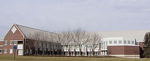
The Brooklyn Park City Hall in November 2006.
|
|||
|
|||
 Location of the city of Brooklyn Park within Hennepin County, Minnesota |
|||
| Coordinates: 45°5′39″N 93°21′22″W / 45.09417°N 93.35611°WCoordinates: 45°5′39″N 93°21′22″W / 45.09417°N 93.35611°W | |||
| Country | United States | ||
| State | Minnesota | ||
| County | Hennepin | ||
| Founded | 1850s | ||
| Incorporated | 1954 | ||
| Government | |||
| • Mayor | Jeffrey Lunde (R) | ||
| Area | |||
| • City | 26.57 sq mi (68.82 km2) | ||
| • Land | 26.07 sq mi (67.52 km2) | ||
| • Water | 0.50 sq mi (1.29 km2) 1.88% | ||
| Elevation | 869 ft (265 m) | ||
| Population (2010) | |||
| • City | 75,781 | ||
| • Estimate (2015) | 79,149 | ||
| • Rank | US: 427th MN: 6th | ||
| • Density | 2,906.8/sq mi (1,122.3/km2) | ||
| • Metro | 3,524,583 (US: 16th) | ||
| Time zone | Central (UTC−6) | ||
| • Summer (DST) | Central (UTC−5) | ||
| ZIP codes | 55428, 55429, 55443, 55444, 55445 | ||
| Area code | 763 | ||
| FIPS code | 27-07966 | ||
| GNIS feature ID | 0640511 | ||
| Website | www.brooklynpark.org | ||
Brooklyn Park is the sixth largest city in the U.S. state of Minnesota. The city is located on the west bank of the Mississippi River, upstream from downtown Minneapolis in northern Hennepin County. Brooklyn Park is a northwest suburb of the Twin Cities Metropolitan area of Minneapolis–Saint Paul.
Brooklyn Park is the second largest suburb of Minneapolis–Saint Paul, the sixteenth largest metropolitan area in the United States, with about 3.52 million residents. The population was 79,149 according to 2015 US census estimates.
Brooklyn Park is listed as a "Tree City USA", and is home to 47 miles of trails, and 67 award-winning parks, including the Rush Creek Regional Trail, and the northern section of the Palmer Lake Park.
The city is also known for the West Coon Rapids Dam, located on the west side of the Mississippi River. North Hennepin Community College and a campus of Hennepin Technical College are located in the city.
Brooklyn Park is the home of Edinburgh USA Golf Course, one of the top public golf courses in the United States.
Brooklyn Park is a "bedroom community" of Minneapolis and Saint Paul, and is considered both a 2nd and 3rd tier suburb because much of the land developed north of 85th Avenue was developed after the year 2000. The city still hosts undeveloped land and farms, including the historic Eidem Homestead, a 1900s working farm that serves as a popular tourist attraction for families and school field trips.
According to the United States Census Bureau, the city has a total area of 26.57 square miles (68.82 km2), of which 26.07 square miles (67.52 km2) is land and 0.50 square miles (1.29 km2) is water.
Interstates 94 and 694 are located in the far southern portion of Brooklyn Park. U.S. Highway 169 is located near the western part of the city. State Highway 252, a 4.5 mile north–south highway, is located near the eastern portion of the city. State Highway 610 runs east–west through the northern portion of Brooklyn Park. County Road 81 also serves as one of the main routes.
...
Wikipedia


