Brione, Switzerland
| Brione | ||
|---|---|---|
 |
||
|
||
| Coordinates: 46°18′N 8°48′E / 46.300°N 8.800°ECoordinates: 46°18′N 8°48′E / 46.300°N 8.800°E | ||
| Country | Switzerland | |
| Canton | Ticino | |
| District | Locarno | |
| Government | ||
| • Mayor | Sindaco | |
| Area | ||
| • Total | 48.56 km2 (18.75 sq mi) | |
| Elevation | 756 m (2,480 ft) | |
| Population (Dec 2016) | ||
| • Total | 175 | |
| • Density | 3.6/km2 (9.3/sq mi) | |
| Postal code | 6634 | |
| SFOS number | 5095 | |
| Surrounded by | Cevio, Gerra (Verzasca), Gordevio, Lavertezzo, Lavizzara, Sonogno | |
| Website |
http://www.brioneverzasca.ch/ SFSO statistics |
|
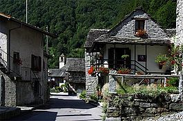
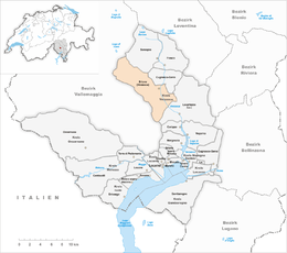
Brione (Verzasca) is a municipality in the district of Locarno in the canton of Ticino in Switzerland.
During the Middle Ages it was part of a squadra in the community of Verzasca. Later, it formed a Vicinanza together with Gerra. In 1852 they both became independent municipalities. As one of the main towns of the upper valley, it and Vogorno alternately presented the candidates for the offices of Podestà and governor. The Castello Marcacci was built in Brione in the 17th Century and was the summer residence of a traditional Podesta family, the Marcacci.
The Church of Beata Vergine Assunta (expanded in the 17th Century and restored in the 19th Century) stands on the remains of a chapel from 1295 and contains frescoes from the 14th (Giotto school in Rimini) and the 15th Centuries. The parish separated from Vogorno before 1518. In 1644, it established a fund to support a school and chaplain.
The local economy was built mainly around agriculture and grazing. The seasonal migration is well documented since 1600. Since the 14th Century many of the residents have spent their winters with their cattle in the Magadino valley.
Brione has an area, as of 1997[update], of 48.56 square kilometers (18.75 sq mi). Of this area, 0.61 km2 (0.24 sq mi) or 1.3% is used for agricultural purposes, while 23.15 km2 (8.94 sq mi) or 47.7% is forested. Of the rest of the land, 0.34 km2 (0.13 sq mi) or 0.7% is settled (buildings or roads), 1.03 km2 (0.40 sq mi) or 2.1% is either rivers or lakes and 20.98 km2 (8.10 sq mi) or 43.2% is unproductive land.
...
Wikipedia


