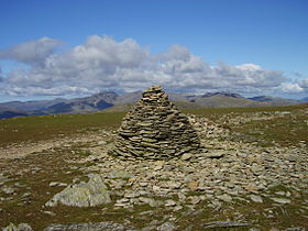
Brim Fell
| Brim Fell | |
|---|---|

Brim Fell summit
|
|
| Highest point | |
| Elevation | 796 m (2,612 ft) |
| Prominence | c. 25 m |
| Parent peak | The Old Man of Coniston |
| Listing | Wainwright, Nuttall |
| Coordinates | 54°22′40″N 3°07′26″W / 54.37766°N 3.12381°WCoordinates: 54°22′40″N 3°07′26″W / 54.37766°N 3.12381°W |
| Geography | |
| Location | Cumbria, England |
| Parent range | Lake District, Southern Fells |
| OS grid | SD271986 |
| Topo map | OS Landranger 89,90, Explorer OL6 |
Brim Fell is a fell in the English Lake District. It stands to the west of Coniston village in the southern part of the District.
The Coniston (or Furness) Fells form the watershed between Coniston Water and the Duddon valley to the west. The range begins in the north at Wrynose Pass and runs south for around 10 miles before petering out at Broughton in Furness on the Duddon Estuary. Alfred Wainwright in his influential Pictorial Guide to the Lakeland Fells took only the northern half of the range as Lakeland proper, consigning the lower fells to the south to a supplementary work The Outlying Fells of Lakeland. Brim Fell occupies a position in the northern section and therefore qualifies as one of the 214 Wainwrights. Later guidebook writers have chosen to include the whole range in their main volumes.
The higher northern part of the Coniston range can be likened to an inverted 'Y' with Brim Fell at the connecting point of the three arms. To the north are Swirl How, Great Carrs and Grey Friar, south east is the short spur terminating at The Old Man of Coniston and to the south west the range continues over Dow Crag to the lower hills beyond.
Brim Fell is unusual in having no footing on the valley floor on either side of the ridge. On the east its boundary streams converge at 800 ft and the flanks of Coniston Old Man and Wetherlam continue to the lake. Above the Duddon, Brim Fell is nipped off by Dow Crag and Grey Friar at an even greater altitude. The area of the fell is therefore small, but full of interest.
The western slopes are relatively smooth and fall to Tarn Head Beck. This runs parallel to the ridge and is the main feeder of Seathwaite Tarn, a reservoir in a side valley of the Duddon system. This was originally a much smaller waterbody, but was dammed early in the 20th century to provide drinking water for the Barrow-in-Furness area. The dam is almost 400 yards long and is concrete cored with slate buttresses, the resulting depth of the tarn being around 80 ft. Water is not abstracted directly from the tarn, but flows some distance downriver to an off-take weir. On the slopes of Brim Fell, above the head of the reservoir, are the remains of Seathwaite Tarn Mine. This was worked for copper in the mid-19th century, and also appears as a location in the novel The Plague Dogs by Richard Adams.
...
Wikipedia

