Dow Crag
| Dow Crag | |
|---|---|

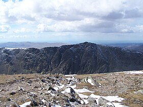
Dow Crag from the Old Man of Coniston summit
|
|
| Highest point | |
| Elevation | 778 m (2,552 ft) |
| Prominence | 129 m (423 ft) |
| Parent peak | The Old Man of Coniston |
| Listing | Hewitt, Nuttall, Wainwright |
| Coordinates | 54°22′10″N 3°08′15″W / 54.36944°N 3.13744°WCoordinates: 54°22′10″N 3°08′15″W / 54.36944°N 3.13744°W |
| Geography | |
| Location | Cumbria, England |
| Parent range | Lake District, Southern Fells |
| OS grid | SD262977 |
| Topo map | OS Landrangers 96, 97, Explorer OL6 |
Dow Crag is a fell in the English Lake District near Coniston, Cumbria. The eastern face is one of the many rock faces in the Lake District used for rock climbing.
The name Dow Crag originally applied specifically to the eastern face which looks down upon the tarn of Goat's Water, the fell itself having no need for a name before the inception of hill walking in the 19th century. As with many fells the name of a prominent feature was then applied to the whole mass. Dow was originally named Doe and still locally pronounced as "Doe".
The Coniston (or Furness) Fells form the watershed between Coniston Water and the Duddon Valley to the west. The range begins in the north at Wrynose Pass and runs south for around 10 miles before petering out at Broughton in Furness on the Duddon Estuary. Alfred Wainwright in his influential Pictorial Guide to the Lakeland Fells took only the northern half of the range as Lakeland proper, consigning the lower fells southward to a supplementary work The Outlying Fells of Lakeland. Dow Crag is the last fell in the northern section of the range and therefore qualifies as one of the 214 Wainwrights. Later guidebook writers have chosen to include the whole range in their main volumes.
The higher northern part of the range can be likened to an inverted 'Y' in plan. Brim Fell stands at the junction of the three arms with the northern branch continuing over Swirl How and Great Carrs. The south western branch traverses to Dow Crag and the south eastern to The Old Man of Coniston, with Goat's Water lying in a deep depression between the two. The connecting ridge from Dow Crag to Brim Fell crosses the depression of Goat's Hawse above the head of the tarn, the Dow Crag side in particular being steep and rough.
...
Wikipedia

