Brighton, Franklin County, New York
| Brighton, Franklin County, New York |
|
|---|---|
| Town | |

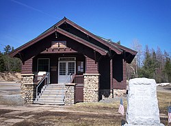
Brighton Town Hall, Benjamin A. Muncil, 1914
|
|
| Location within the state of New York | |
| Coordinates: 44°26′27″N 74°13′56″W / 44.44083°N 74.23222°WCoordinates: 44°26′27″N 74°13′56″W / 44.44083°N 74.23222°W | |
| Country | United States |
| State | New York |
| County | Franklin |
| Government | |
| • Type | Town Council |
| • Town Supervisor | John Quenell (D) |
| • Town Council |
Members' List
|
| Area | |
| • Total | 83.0 sq mi (215.0 km2) |
| • Land | 77.9 sq mi (201.7 km2) |
| • Water | 5.1 sq mi (13.2 km2) |
| Elevation | 1,880 ft (573 m) |
| Population (2010) | |
| • Total | 1,435 |
| • Density | 18/sq mi (7.1/km2) |
| Time zone | Eastern (EST) (UTC-5) |
| • Summer (DST) | EDT (UTC-4) |
| FIPS code | 36-08213 |
| GNIS feature ID | 0978752 |
| Website | townofbrighton |
Brighton is a town in Franklin County, New York, United States. The population was 1,435 at the 2010 census. It was named after Brighton, England, by early surveyors in the region.
The town is in the southern part of the county and is inside the Adirondack Park. Paul Smith's College is in the community of Paul Smiths, a hamlet of Brighton.
The first settlers in this area arrived around 1815. The town of Brighton was set aside from the Duane in 1858. James M. Wardner was elected its first supervisor. Apollos "Paul" Smith arrived in 1859 and gradually built up a hotel in the community that bears his name. Having become an important Adirondack hotel, Paul Smith's College was established by his family. The college now uses the land where the hotel once stood along Lower St. Regis Lake. Also around that time James Wardner had a small hotel on Rainbow Lake.
Among the "second round" of settlers in the town of Brighton after its pioneers Follensby, S. Johnson, the Rice brothers, Amos and Levi; Oliver Keese and Thomas A. Tomlinson; James and Seth Wardner, were the Ricketsons, the Rands, the Dustins, Jute Q. King and his son, Philemon King. They were scattered along the highway from Keese Mill and McColloms to Paul Smiths to Easy Street to the Split Rock Road and to Rainbow Lake and Jones Pond.
The hamlet now called Gabriels originated back when only the Rands, the Ricketsons, the Dustins, and the Otises were settled on farms nearer to the Split Rock Road and Ricketson Brook in the southern part of the town along the boundary with the town of Harrietstown than where Gabriels is currently situated. It wasn't until the Adirondack & St. Lawrence Railway came in 1892 that Gabriels expanded northward, with many settling near the railroad station. Following the arrival of the railroad, the Sisters of Mercy came to the town and established a tuberculosis sanitorium, and Muncil's sawmill was founded. Paul Smith's Hotel immediately started a stage line to the railroad station. The Gabriels Sanatorium, opened in 1897, later became Camp Gabriels, a minimum-security state prison.
...
Wikipedia

