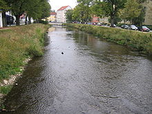
Brigach

The Brigach in Donaueschingen
|
|
| Country | Germany |
|---|---|
| Location | Schwarzwald-Baar-Kreis, Baden-Württemberg |
| Reference no. | DE: 1112 |
| Basin features | |
| Main source | in Brigach near St. Georgen im Schwarzwald ca. 925 m above sea level (NHN) 48°06′24″N 8°16′51″E / 48.10667°N 8.28083°ECoordinates: 48°06′24″N 8°16′51″E / 48.10667°N 8.28083°E |
| River mouth | Confluence: with the Breg to form the Danube east of Donaueschingen ca. 672 m above sea level (NN) 47°57′03″N 8°31′13″E / 47.950972°N 8.5201833°E |
| Progression | Danube → Black Sea |
| River system | Danube |
| Basin size | 196.690 km² |
| Landmarks |
|
| Physical characteristics | |
| Length | 40.473 km (25.149 mi) |
| Discharge |
|
The Brigach is the shorter of two streams that jointly form the river Danube in Baden-Württemberg, Germany. The Brigach has its source at 925 m (3,035 ft) above sea level within St. Georgen in the Black Forest. The Brigach crosses the city Villingen-Schwenningen. 43 km (27 mi) from the source, the Brigach joins the Breg in Donaueschingen to form the Danube River.
The name Brigach is of Celtic origin and means "light coloured, pure water". A relief found here points to the goddess, Abnoba.
One source of the Brigach is impounded in the cellar of a farmhouse in the upper valley near the village of Brigach and may be visited by the public. On the official state water map the Brigach begins, however, at a height of about 925 m above NHN somewhat below a small pond near this farm in the borough of Sankt Georgen im Schwarzwald.
The Brigach flows initially along a gently descending course and roughly east-north-east through the landscape of the Black Forest, which consists here of open fields across the width of the valley with woods on the accompanying heights, before reaching the first large village of Sankt Georgen. From here Baden's Black Forest Railway runs down to the mouth of the valley. In Sankt Georgen, the river is already 100 metres below the surrounding highland and it now swings slowly around the woods of the Röhlinswald on the right to head southeast through a typical high Black Forest landscape of scattered settlements. By the place where the Brigach is joined from the WNW by its first long tributary, the Röhlinsbach, it leaves the parish of Sankt Georgen and enters a valley called the Groppertal, a protected landscape about half a square kilometre in area, which lies within the municipality of Unterkirnach and the town of Villingen-Schwenningen. It continues down the valley until it is joined, near Kirnach railway station outside the village of Villingen, by its most important tributary, the Kirnach which has a length of over 12 kilometres and a catchment of 33 km². In this area the Birgach runs for just under a quarter of a kilometre alongside the railway line which itself runs close to the right side of the valley, below the hillside.
...
Wikipedia
