Briar Creek Township, Columbia County, Pennsylvania
| Briar Creek Township, Pennsylvania | |
|---|---|
| Township | |

The Old Stone Church in the township, built 1808
|
|
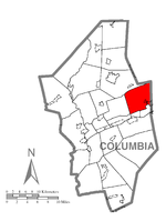
 Map of Columbia County, Pennsylvania highlighting Briar Creek Township |
|
 Map of Columbia County, Pennsylvania |
|
| Country | United States |
| State | Pennsylvania |
| County | Columbia |
| Settled | 1793 |
| Incorporated | 1797 |
| Area | |
| • Total | 21.2 sq mi (54.8 km2) |
| • Land | 21.0 sq mi (54.3 km2) |
| • Water | 0.2 sq mi (0.6 km2) |
| Population (2010) | |
| • Total | 3,016 |
| • Density | 144/sq mi (55.6/km2) |
| Time zone | Eastern (EST) (UTC-5) |
| • Summer (DST) | EDT (UTC-4) |
| Area code(s) | 570 |
| Website | www |
Briar Creek Township is a township in Columbia County, Pennsylvania, United States. The population was 3,016 at the 2010 census.
Briar Creek Township is in eastern Columbia County, bordered to the east by Luzerne County, to the north by Fishing Creek Township, to the west by North Centre Township, and to the south by the boroughs of Briar Creek and Berwick. The unincorporated community of Foundryville is in the southeast corner of the township, adjacent to Berwick.
The northern boundary of the township follows the ridgecrest of Huntington Mountain, while Lee Mountain is south of it, running nearly parallel to it. The two ridges converge to form Knob Mountain, which is primarily west of the township. According to the United States Census Bureau, the township has a total area of 21.2 square miles (54.8 km2), of which 21.0 square miles (54.3 km2) is land and 0.23 square miles (0.6 km2), or 1.04%, is water.
As of the census of 2000, there were 3,061 people, 1,225 households, and 911 families residing in the township. The population density was 145.2 people per square mile (56.1/km²). There were 1,351 housing units at an average density of 64.1/sq mi (24.7/km²). The racial makeup of the township was 99.18% White, 0.20% African American, 0.03% Native American, 0.10% Asian, 0.23% from other races, and 0.26% from two or more races. Hispanic or Latino of any race were 0.39% of the population.
...
Wikipedia
