Breil-sur-Roya
| Breil-sur-Roya | ||
|---|---|---|

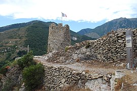
The tower of Cruella, in Breil-sur-Roya
|
||
|
||
| Coordinates: 43°56′17″N 7°30′54″E / 43.9381°N 7.515°ECoordinates: 43°56′17″N 7°30′54″E / 43.9381°N 7.515°E | ||
| Country | France | |
| Region | Provence-Alpes-Côte d'Azur | |
| Department | Alpes-Maritimes | |
| Arrondissement | Nice | |
| Canton | Breil-sur-Roya | |
| Government | ||
| • Mayor (2008–2014) | Joseph Ghilardi | |
| Area1 | 81.31 km2 (31.39 sq mi) | |
| Population (2008)2 | 2,117 | |
| • Density | 26/km2 (67/sq mi) | |
| Time zone | CET (UTC+1) | |
| • Summer (DST) | CEST (UTC+2) | |
| INSEE/Postal code | 06023 /06540 | |
| Elevation | 151–2,080 m (495–6,824 ft) (avg. 310 m or 1,020 ft) |
|
|
1 French Land Register data, which excludes lakes, ponds, glaciers > 1 km² (0.386 sq mi or 247 acres) and river estuaries. 2Population without double counting: residents of multiple communes (e.g., students and military personnel) only counted once. |
||
1 French Land Register data, which excludes lakes, ponds, glaciers > 1 km² (0.386 sq mi or 247 acres) and river estuaries.
Breil-sur-Roya (Italian: Breglio sul Roia or simply Breglio, Ligurian: Breggio, Occitan: Brelh de Ròia) is a commune in the Alpes-Maritimes department in southeastern France.
Breil-sur-Roya is one of the towns on the route of the Train des Merveilles which runs between Nice and Cuneo in Italy.
The GR52, part of the French Grande Randonnée walking trail network links the town to Gorges de Saorge and Vallon de Zouayne.
Breil-sur-Roya is particularly known for trout fishing. The Roya river runs through town and is open to trout anglers from March to September. Part of the trout run is reserved for fly-fishing. Trout anglers share the river with rafters, another popular local sport.
Breil-sur-Roya is twinned with:
...
Wikipedia


