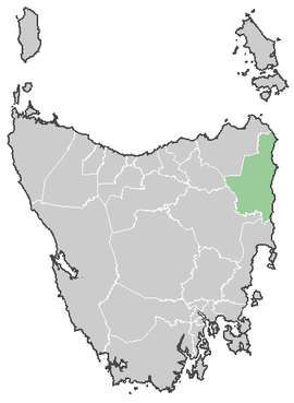
Break O'Day
|
Break O'Day Council Tasmania |
|||||||||||||
|---|---|---|---|---|---|---|---|---|---|---|---|---|---|

Break O'Day Council
|
|||||||||||||
| Coordinates | 41°27′18″S 148°04′44″E / 41.45500°S 148.07889°ECoordinates: 41°27′18″S 148°04′44″E / 41.45500°S 148.07889°E | ||||||||||||
| Population | 6,469 (2015 est) | ||||||||||||
| • Density | 1.8/km2 (4.7/sq mi) | ||||||||||||
| Area | 3,525.8 km2 (1,361.3 sq mi) | ||||||||||||
| Mayor | Mick Tucker | ||||||||||||
| Council seat | St Helens | ||||||||||||
| Region | Northern east coast | ||||||||||||
| State electorate(s) | Lyons | ||||||||||||
| Federal Division(s) | Lyons | ||||||||||||
 |
|||||||||||||
| Website | Break O'Day Council | ||||||||||||
|
|||||||||||||
The Break O'Day Council is a local government area of Tasmania, encompassing the northern part of the state's east coast.
Major towns in the area include St Helens, St Marys, Scamander, Beaumaris, Fingal, Mathinna and the valley of Pyengana. Break O'Day also has one of the state's highest waterfalls, St. Columba, with Halls Falls and Ralphs Falls nearby.
Break O'Day Council is one of the few places in Australia having above replacement fertility rate. The fertility rate was 2.35 in 2001 and 2.21 in 2006.
Break O'Day Council is composed of nine Councillors elected using the Hare-Clark system of proportional representation as a single ward. All Councillors are elected for a fixed four-year term of office. The Mayor and Deputy Mayor are each directly elected for a four-year term. The Mayor and Deputy Mayor must also be elected as Councillors in order to hold office. Elections are normally held in October, with the next election due to be held in October 2018. Neither the Australian Labor Party nor the Liberal Party of Australia endorse local government candidates in Tasmania.
The most recent election of Councillors was held over a two-week period from 14 October to 28 October 2014, and the makeup of the Council is as follows:
The current Council, elected in 2014, in order of election, is:
...
Wikipedia
