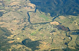
Fingal, Tasmania
|
Fingal Tasmania |
|
|---|---|

Aerial photo from south east. South Esk River visible.
|
|
| Population | 366 (2011 census) |
| • Density | 79.6/km2 (206/sq mi) |
| Established | 1827 |
| Postcode(s) | 7214 |
| Elevation | 232 m (761 ft) |
| Area | 4.6 km2 (1.8 sq mi) |
| Location |
|
| LGA(s) | Break O'Day Council |
| State electorate(s) | Lyons |
| Federal Division(s) | Lyons |
Fingal /fɪŋˈɔːl/ is a small Australian town in Fingal Valley in the north-east of Tasmania, on the Esk Highway.
The Fingal area was surveyed in 1824 by Roderic O'Connor and John Helder Wedge, and is believed to have been named after Fingal's Cave in the Inner Hebrides of Scotland rather than Fingal in Ireland. The town of Fingal came into existence in 1827 as a convict station, and experienced a boom when Van Diemen's Land's first payable gold was discovered in nearby Mangana.
Fingal Post Office opened on 1 June 1832.
Coordinates: 41°38′19″S 147°58′02″E / 41.6386°S 147.9672°E
...
Wikipedia
