Bracebridge, Ontario
| Bracebridge | |
|---|---|
| Town (lower-tier) | |
| Town of Bracebridge | |

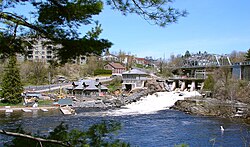
View of the road into central Bracebridge.
|
|
| Motto: The Heart of Muskoka | |
| Coordinates: 45°02′N 79°18′W / 45.033°N 79.300°WCoordinates: 45°02′N 79°18′W / 45.033°N 79.300°W | |
| Country |
|
| Province |
|
| District | Muskoka |
| Incorporated | 1875 (village) |
| Incorporated | 1889 (town) |
| Government | |
| • Mayor | Graydon Smith |
| • Governing Body | Bracebridge Town Council |
| • Federal riding | Parry Sound—Muskoka |
| • Prov. riding | Parry Sound—Muskoka |
| Area | |
| • Land | 628.22 km2 (242.56 sq mi) |
| Population (2016) | |
| • Total | 16,010 |
| • Density | 25.5/km2 (66/sq mi) |
| Time zone | EST (UTC−5) |
| • Summer (DST) | EDT (UTC−4) |
| Postal code FSA | P1L |
| Area code(s) | 705 & 249 |
| Highways |
|
| Website | www.bracebridge.ca |
Bracebridge is a town and the seat of the Muskoka District Municipality in Ontario, Canada.
The town was built around a waterfall on the Muskoka River in the centre of town, and is known for its other nearby waterfalls (Wilson's Falls, High Falls, etc.). It was first incorporated in 1875. It was named after a book, Bracebridge Hall by Washington Irving, that the postmaster in charge of naming towns was reading at the time.
The town is the seat of the district government, a centre of tourism for the Muskoka area, and home to several historical sites, such as the Inn at the Falls, Woodchester Villa, and the Silver Bridge, which joins Manitoba Street with Ecclestone Drive. The Silver Bridge was repaired in 2002. Bracebridge is also the home of the Muskoka Cottage Brewery.
Graydon Smith is the current mayor.
The character of the town of Bracebridge is shaped by its proximity to Lake Muskoka to which it is connected by 6 miles of the Muskoka River, and by the promise of abundant water power afforded by the great waterfall at the foot of the town. Early growth of the town occurred in proximity to the falls which powered the first factory. The arrival of the Grand Trunk Railway cemented the town's role as a transportation hub for the area.
Modern settlement of the town began in the 1860s, beginning at first with a few log huts. The Muskoka colonization road had been completed to the first falls on the north branch of the Muskoka River by 1862. Entrepreneurs began to take advantage of the area's water power. With the advent of steamship service on Lake Muskoka a few years later, Bracebridge prospered as the main distribution centre for the region.
By 1869, Bracebridge was a village with a population of 160 in the Township of Macaulay County, Victoria. It was established on the Muskoka River. There were stages in winter and boats in summer from Barrie to Washago. The average price of wild land was $2 to $5 an acre while improved land was $10 per acre.
By 1870 the village had a population of about 400, growing to reach a total of about 2,000 by the turn of the 20th century. The village was incorporated in 1875 and became a town under an Act of Parliament in 1889. In 1894 Bracebridge became the first town in Ontario to have its own hydro generating station.
...
Wikipedia

