Brač

|
|
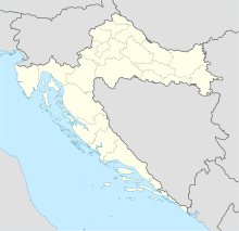
| Location of Brač | |
| Geography | |
|---|---|
| Location | Adriatic Sea |
| Coordinates | 43°19′N 16°38′E / 43.317°N 16.633°E |
| Archipelago | Dalmatian Archipielago |
| Area | 396 km2 (153 sq mi) |
| Highest elevation | 780 m (2,560 ft) |
| Highest point | Vidova gora |
| Administration | |
|
Croatia
|
|
| County | Split-Dalmatia |
| Largest settlement | Supetar (pop. 3,326) |
| Demographics | |
| Population | 13956 (2011) |
| Pop. density | 35 /km2 (91 /sq mi) |
| Ethnic groups | Croats |
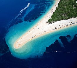
Brač (pronounced [brâːtʃ]; local Chakavian: Broč, pronounced [broːtʃ]; Latin: Bretia, Brattia; Italian: Brazza) is an island in the Adriatic Sea within Croatia, with an area of 396 square kilometres (153 sq mi), making it the largest island in Dalmatia, and the third largest in the Adriatic. It is separated from the mainland by the Brač Channel, which is 5 to 13 km (3 to 8 mi) wide. The island's tallest peak, Vidova gora, or Mount St. Vid, stands at 780 m, making it the highest island point in the Adriatic. The island has a population of 13,956, living in numerous settlements, ranging from the main town Supetar, with more than 3,300 inhabitants, to Murvica, where less than two dozen people live. Bol Airport on Brač is the largest airport of all islands surrounding Split.
Archaeological findings date the existence of human communities on the island back to the palaeolithic (in the Kopačina cave between Supetar and Donji Humac). Nevertheless, there are no traces of human habitation from the neolithic. In the Bronze Age and Iron Age, Illyrian tribes populated the inner parts of the island. Numerous villages existed at that time (but none of them survived).
...
Wikipedia

