Bouzonville
| Bouzonville | ||
|---|---|---|

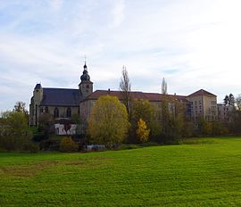
Bouzonville, Buildings of the former Abbey Sainte Croix upon the Nied
|
||
|
||
| Coordinates: 49°17′33″N 6°32′06″E / 49.2925°N 6.535°ECoordinates: 49°17′33″N 6°32′06″E / 49.2925°N 6.535°E | ||
| Country | France | |
| Region | Grand Est | |
| Department | Moselle | |
| Arrondissement | Forbach-Boulay-Moselle | |
| Canton | Bouzonville | |
| Intercommunality | Bouzonvillois | |
| Government | ||
| • Mayor (2008–2014) | Gilbert Philipp | |
| Area1 | 13.9 km2 (5.4 sq mi) | |
| Population (2009)2 | 4,154 | |
| • Density | 300/km2 (770/sq mi) | |
| Time zone | CET (UTC+1) | |
| • Summer (DST) | CEST (UTC+2) | |
| INSEE/Postal code | 57106 /57320 | |
| Elevation | 192–310 m (630–1,017 ft) (avg. 190 m or 620 ft) |
|
|
1 French Land Register data, which excludes lakes, ponds, glaciers > 1 km² (0.386 sq mi or 247 acres) and river estuaries. 2Population without double counting: residents of multiple communes (e.g., students and military personnel) only counted once. |
||
1 French Land Register data, which excludes lakes, ponds, glaciers > 1 km² (0.386 sq mi or 247 acres) and river estuaries.
Bouzonville (German: Busendorf, Lorraine Franconian: Busendroff) is a commune in the Moselle department in Grand Est in northeastern France.
The localities of Aidling, Benting and Heckling are incorporated in the commune. It lies 35 km (22 mi) from Metz and the same distance from Thionville.
Built on the "salt road" between the Rhine and the Moselle, at the site of an easy ford of the Nied, the site's traces of Celtic La Tène culture are most vividly represented by the "Bouzonville flagon", in which Scythian influence on Celtic craftsmenship is clearly represented in the animal that forms its handle and in the nature of coral inlays, with enamels of similar colour supplementing it, that form bands around the base and rim of the high-shouldered vessel; the beak-flagon was among a group of bronze objects from Bouzonville acquired by the British Museum in 1928. A minor Roman vicus represented by tiles that the plough turns up, complements the few signs of prehistory, though essentially pre-historic is the mute Merovingian necropolis of more than a hundred graves, holding twice as many women as men, 0.5 km (0.31 mi) east of the town; there is no trace of their habitations, which apparently supplied the villa attached to the -ville toponym. There is no agreement on the identity of the other element, apparently of one of the numerous Frankish magnates named Boso.
...
Wikipedia


