Bourke Isles

A Landsat image of Yam Island, one of the Bourke Isles
|
|

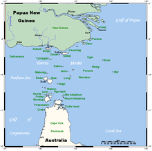
A map of the Torres Strait Islands showing Yam Island as Iama in central waters of the Torres Strait
|
|
| Etymology | Richard Bourke |
|---|---|
| Geography | |
| Location | Cumberland Passage, Northern Australia |
| Coordinates | 9°54′00″S 143°23′41″E / 9.8999°S 143.3947°ECoordinates: 9°54′00″S 143°23′41″E / 9.8999°S 143.3947°E |
| Archipelago | Torres Strait Islands |
| Adjacent bodies of water | Torres Strait |
| Total islands | 7 |
| Major islands | Yam Island |
| Administration | |
| State | Queensland |
| Local government area | Torres Strait Island Region |
| Demographics | |
| Ethnic groups | Torres Strait Islanders |
The Bourke Isles are a group of islands in the Torres Strait Islands archipelago, located west of the Cumberland Passage in the Torres Strait in Queensland, Australia. The isles are situated approximately 130 kilometres (81 mi) northeast of Thursday Island and 54 kilometres (34 mi) southwest of Darnley Island. The Bourke Isles are located within the Torres Strait Island Region local government area.
The islands were named in 1836 by Charles Lewis, the Commander of colonial schooner Isabella, in honour of Richard Bourke, at the time, the Governor of New South Wales.
The Bourke Isles includes:
...
Wikipedia
