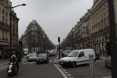
Boulevard de Magenta

View of boulevard de Magenta
|
|
| Length | 1,920 m (6,300 ft) |
|---|---|
| Width | 30 m (98 ft) |
| Arrondissement | 9th, 10th |
| Quarter | quartier Saint-Vincent-de-Paul quartier de la Porte-Saint-Denis quartier de la Porte-Saint-Martin |
| From | place de la République |
| To | boulevard de la Chapelle |
| Construction | |
| Completion | 1855 and 1859 |
| Denomination | 1855 |
The boulevard de Magenta is located in the Ninth and Tenth arrondissements of Paris, France.
It begins at place de la République and 1, rue Beaurepaire, and ends at 1, boulevard de Rochechouart and 53, boulevard de la Chapelle.
It is named after the battle of Magenta, a battle fought on 4 June 1859 near Magenta in Italy. It was a victory by the Piedmontais of the kingdom of Piedmont-Sardinia and by the French armée d'Italie under general Mac-Mahon and Napoléon III over the Austrians under Guylay.
The creation of the boulevard de Magenta was part of the Hausmannian transformation of Paris. It was completed in 1855 between rue du Faubourg-Saint-Martin and the boulevard de Rochechouart (the boulevard here in fact follows the route of the old rue du Nord which formed a part of an 1827 subdivision) and in 1859 between place de la République and rue du Faubourg-Saint-Martin.
The RER station Magenta is located to the east of the gare du Nord and named after this boulevard, even if it is not truly under it. It is served by RER line E.
Coordinates: 48°52′32″N 2°21′24″E / 48.87556°N 2.35667°E
...
Wikipedia

