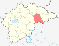
Borovichsky District
| Borovichsky District Боровичский район (Russian) |
|
|---|---|
 Location of Borovichsky District in Novgorod Oblast |
|
| Coordinates: 58°16′N 34°07′E / 58.267°N 34.117°ECoordinates: 58°16′N 34°07′E / 58.267°N 34.117°E | |
|
|
|
| Location | |
| Country | Russia |
| Federal subject | Novgorod Oblast |
| Administrative structure (as of February 2013) | |
| Administrative center | town of Borovichi |
| Administrative divisions: | |
| Settlements | 10 |
| Inhabited localities: | |
| Rural localities | 323 |
| Municipal structure (as of March 2013) | |
| Municipally incorporated as | Borovichsky Municipal District |
| Municipal divisions: | |
| Urban settlements | 1 |
| Rural settlements | 16 |
| Statistics | |
| Area (municipal district) | 3,100 km2 (1,200 sq mi) |
| Population (2010 Census) | 15,675 inhabitants |
| • Urban | 0% |
| • Rural | 100% |
| Density | 5.06/km2 (13.1/sq mi) |
| Time zone | MSK (UTC+03:00) |
| Established | October 1, 1927 |
| Official website | |
| on | |
Borovichsky District (Russian: Боровичский райо́н) is an administrative and municipal district (raion), one of the twenty-one in Novgorod Oblast, Russia. It is located in the east of the oblast and borders with Khvoyninsky District in the north, Moshenskoy District in the east, Udomelsky District of Tver Oblast in the southeast, Bologovsky District of Tver Oblast in the south, Okulovsky District in the west, and with Lyubytinsky District in the northwest. The area of the district is 3,100 square kilometers (1,200 sq mi). Its administrative center is the town of Borovichi (which is not administratively a part of the district). Population: 15,675 (2010 Census); 19,085 (2002 Census);21,648 (1989 Census).
Borovichsky District is located in the northeastern part of the Valday Hills in the basin of the Msta River. The Msta crosses the district from southeast to northwest. Msta's rapids are located in the district. The principal tributaries of the Msta within the limits of the district are the Uver and the Velgiya; both are right. The northeast of the district lies in the basin of the tributaries of the Uver, of which the Udina is the biggest one.
...
Wikipedia

